« June 2008 | Main | August 2008 »
July 25, 2008
Fairbanks back to the BC border
It’s just under 200 km from Denali to Fairbanks and the road is very good, so it was an easy drive. Jane is flying home from Fairbanks on Saturday so we headed there on Thursday, July 10th to give us a full day to see the city before she left.
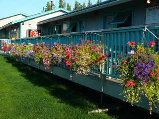 We stayed at a campground on the west side of the city, right beside the Chena River and close to the airport. A nice park with beautiful hanging baskets and a lovely trail along the river bank. On Jane’s last evening with us, the three of us walked to a restaurant just a bit down the river and had an excellent meal. Jane said the crab cakes were the best she had ever had!
 Fairbanks was founded in 1903 with the discovery of gold nearby. (Seems like most of the north was founded because of minerals or the fur trade!) It is right in the heart of the interior and is the northern terminus of the Alaska railroad as well as the Richardson Highway.
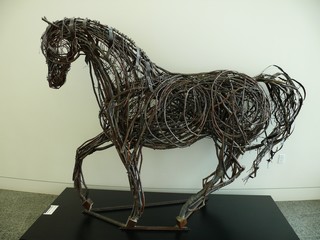
The comprehensive Museum of the North and art gallery is found on the University Grounds and we spent a couple of hours visiting it. There was a wonderful sculpture there – made from wood and wire.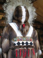
In the afternoon, we all took the Riverboat Discovery cruise on the Chena River and were treated to a sea plane demonstration, a visit with a sled dog team and time in a native village.
This was a beautifully made and decorated fur coat.
On Saturday morning we said farewell to Jane, at the Fairbanks airport as she headed home to Toronto. It was a great visit and we were all amazed at how quickly the days sped past.
This was the first time that we had anyone stay with us in the trailer for any length of time. Although it was tight quarters at times we think it was very successful and were very pleased that she had come north.
 Fairbanks was our turning location. From there on July 13th, we started to head back east and south.
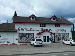
Just outside Fairbanks is the city of North Pole and of course, there had to be a Santa Claus House.
This is the biggest Christmas store we have every seen and inside the store is a post box where you can mail your letters and have them postmarked “North Pole”. Kind of neat!!
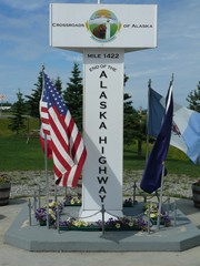
About 160km southeast of Fairbanks is Delta Junction, the official northern end of the Alaska Highway.
We stood at this monument, 1,422 miles from the beginning of the road in Dawson Creek. Although we had not travelled it continuously, it was the guideline of our travel and we did complete the total length as we returned to Whitehorse.
The highway just east of Tok had numerous sections of road construction and then just inside the Canadian border to about Destruction Bay the road was horrible. That whole section is frost heaves, washouts, cracking and generally unstable. We were told that there has been mountains of money spent on it but the ground is unstable and nothing lasts. We travelled slowly and were glad to find a campsite in Destruction Bay at the end of the second day.
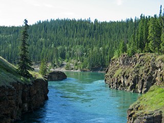
We reached Whitehorse on July 15th, the third day of driving. The highway follows the eastern boundary of Kluane Wildlife Sanctuary and a section of Kluane National Park. Kluane is not accessible by road so we were only able to see it from the edges.
It’s a big park, 8,500 square miles and contains Canada’s highest peak, Mt. Logan. At a little over 19,500 feet high you would think it could be seen, but not so – it’s way into the park, probably at least 100 km from the closest road. It is the second highest mountain in North America – topped only by Mt. McKinley.
 We only spent one night in Whitehorse as we had been there on our way north.
We did however visit Miles Canyon which was famous for its rapids which required goods be portaged around them. With the building of a dam, the rapids have disappeared but the canyon is still there although not as dramatic as before.
We continued south to Teslin where we camped at Mukluk Annie’s. Now that’s a deal! If you eat at the restaurant, you get to dry camp free (good sites at the lake), power wash your truck and trailer for free and take an evening pontoon boat ride for free (donations accepted). The food was good and the prices were reasonable.
Our last night in Yukon, July 17th, was at Junction 37 which is where Highway 37 leaves the Alaska Highway and heads south into British Columbia. It’s about 20km west of Watson Lake. The campground was a disappointment. The sites were fine but the grounds were poorly kept. It could be a lovely park if someone cared about it.
British Columbia next.
Bernie & Ross
Posted by Bernice at 06:21 PM | Comments (5)
July 13, 2008
Denali National Park & Preserve
The park began as Mt. McKinley National Park (after the US senator and later US President) in 1917 and went through several size and name changes until 1980 when it was expanded to its current size, with its current name, by an act of the Alaskan legislature. It is now composed of 3 distinct sections – Denali Wilderness, a highly regulated area to maintain its unspoiled parkland characteristics; Denali National Preserve which allows subsistence and sport hunting, fishing and trapping under Alaska regulations; Denali National Park which allows customary and traditional subsistence uses for local resident Alaskans. Overall the park is home to some of the largest North American mammals and some of the smallest plant varieties. Mt. McKinley continues to be the biggest attraction in the park and at 20,320 feet is the highest peak in North America. Of greater importance, is has the greatest vertical exposure, over 18,000 feet, of any mountain in the world including Mt. Everest. That afternoon we went The next morning at 10, we were at the bus depot for our 8 hour park bus tour. Ross on a bus for 8 hours NO WAY, but any way – – – . At Denali you can only drive private vehicles about 15 miles into the park to the Savage River outlook, so they have 2 types of bus trips for visitors. The tours on the Green bus cost about $30 and are like a city bus. They stop at pre-arranged places, but also will pick up people along the way. The drivers are not professional interpretive guides. The tan colour bus trips are about $100, take around 10 hours, include a box lunch and water and carry a professional narrator/guide. The Green Bus trip we chose was to the new Eielson Visitor Centre 66 miles into the park (the road only runs for 89 miles). You take your own food and drink.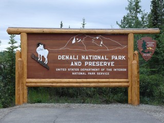 On Tuesday July 8th, we arrived at Denali RV Park and Motel, just north of the National Park. Denali (“High One” in the Athabascan First Nation language, referring to Mt. McKinley) National Park and Preserve is the largest national park at just over 6,000,000 acres and visitors see only a tiny piece of it. The park is bigger than Massachusetts and almost 4 times bigger than Prince Edward Island. Like the Dempster Highway, Denali and Mt McKinley were high on our list of ‘Must See’ places.
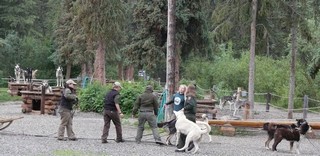 to the Visitor Centre to book a tour and then went to a sled dog demonstration. To preserve the natural environment of Denali, the park is patrolled in winter only by dog team – no motorized vehicles are used. The dogs were on show for our group of about 120 visitors.
Our driver was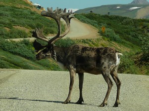 in his fifth year and was terrific. Doing the trip 5 days a week, he knew pretty well where the animals were likely to be. His instruction as we left was that if he was talking and we saw animals we were to yell ‘stop’ and then tell everyone where to look. That day we saw grizzlies, caribou, Dall sheep, moose, black bears, and coyotes ... but no
 One section of the road is built right into the side of the mountain and is only one vehicle wide with shallow widening so that buses can meet. The rule is – the upbound bus has the right of way. We were very glad that we had professional drivers when the buses met on a couple of the curves.
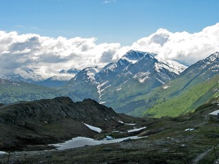
There were two stops each way at panoramic viewpoints. At Eielson we stopped for about an hour and a half, ate our lunch, viewed the exhibits (which were excellent) and took many photos of the magnificent vistas. We both use digital cameras so we just keep shooting and review/edit them back at the trailer at night. 
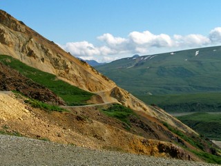
The land is huge – note the road in the bottom right of this photo. There were National Park rangers available to answer questions and point out special features of the area. One of the stops on the return trip was at a very good book store (literally in the middle of nowhere).
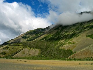
A few more pictures of the scenery:
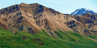
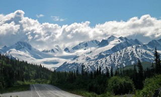
Sweeping hills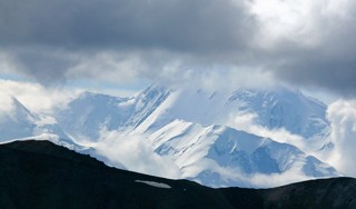
Snow covered mountains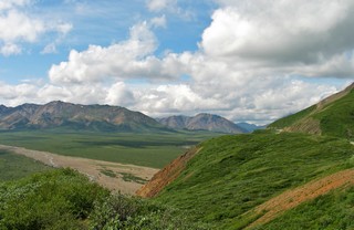
Broad plains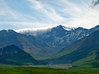
Clouds hugging the mountains.
The mountains make their own weather systems.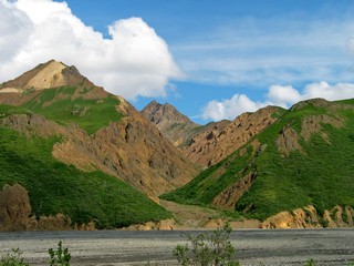
Wide river beds, often with a washed gravel base and many channels of water, intertwined like braided hair.
The trip went quickly and we arrived back at the visitor centre just after 6:30 that evening. A great day!
The Denali town site, just outside the entrance to the park is made up of the usual assortment of convenience restaurants, gift shops and services typically found around a major tourist attraction. But it also has 2 major hospitality facilities; one owned by Princess Cruise Line and the other by Holland-America Cruise Line. They even have their own passenger rail cars used by the Alaska Railroad to bring guests from Fairbanks and Anchorage, every day during the tourist season. In fact, we saw their sight seeing buses and hotels all over Alaska and Yukon – they are a major tourism influence.
Now we head further north to Fairbanks.
Ross & Bernie
Posted by Bernice at 05:52 PM | Comments (1)
July 10, 2008
Valdez, Anchorage & the Kenai Peninsula
 The city of Valdez sits on the north shore of a deep water fjord in Prince William Sound. It developed because it was a debarkation point for men heading to the Klondike gold fields and it had an ice-free port. The original location was destroyed by tsunami caused by the 1964 earthquake and rebuilt about 5km away. It is surrounded by wonderful snow capped mountains – one of the prettiest settings we have encountered.
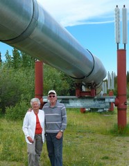
The Trans-Alaska Pipeline runs for 1,300 km (800 miles) from the Arctic Ocean at Prudhoe Bay to its terminus in the Gulf of Alaska at Valdez. Between these two points there were three mountain ranges, rivers and streams, active fault lines, bogs, permafrost and remote terrain. It was completed in 1977 and over half is built above ground where permafrost exists and if it must be buried to cross a highway, if need be it is encased in an insulated, refrigerated ditch. The 48 inch pipeline is visible from many points on the Valdez Highway and we went in to one information and viewing area to get an up close look at it.
 .
.
We left the trailer at Glenallen, about 200km north of Valdez and 300 km east of Anchorage and took only the truck over the mountains. With the number of stops we made for pictures and to marvel at the views, we were very glad that we had left it at the campground.
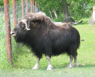 After our visit to Valdez, we next stopped for 3 nights in Palmer, about 30km north west of Anchorage. Close by was the Musk Ox Farm. These animals are prehistoric remnants from the last ice age. We took an excellent tour and saw cows and calves, as well as yearlings and bulls. We learned about quiviut (the under-wool) which is now being used in a textile industry for native communities in Alaska.
While in Palmer we took the opportunity to wash clothes, wash the truck, shop and generally catch up on domestic chores.
Anchorage is a big city – the largest in Alaska at close to 300,000 residents, 360,000 if you include the adjacent communities. It actually lies as far west as the Hawaiian Islands and as far north as Helsinki, Finland. The tides in Cook Inlet rise up to 33 feet and the city is surrounded by mountains. It was only 1915 that Anchorage was established as the construction headquarters for the Alaska Railroad and it is now the transportation and business centre of south-central Alaska.
 We spent two nights right in Anchorage, so that we could be close to the airport to welcome our sister-in-law, Jane, who arrived on July 1st to spend about 12 days with us. She landed safe and sound and not to be caught sitting around, we immediately (after dropping her suitcase at the trailer) took her to the Alaska Museum at Rasmuson Center. This museum gives a wonderful overview of Alaska history from the first explorers to the present.
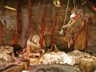
We had visited the Alaska Native Heritage Center earlier in the day. By means of recreated village sites, it presents information about the five regional native groups that inhabit Alaska.
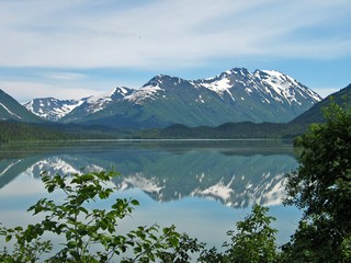 The following morning, Wed, July 2nd we headed south into the Kenai Peninsula. We left early in the morning as we were going to Seward and the city park we were headed for did not take reservations. It was coming up to the 4th of July weekend and we were concerned about getting a spot. As it turned out, they had opened up the ball park for dry camping so we did find room, although by the Thursday that was full as well. It was a beautiful travel day and the reflections on one of the lakes was outstanding.
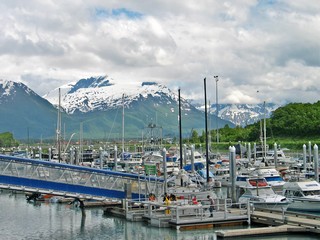
Seward is a major cruise ship and freight port and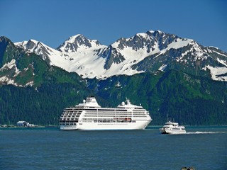 is the southern terminus of the Alaska Railroad which then will take passengers and cargo further into the state to other Alaskan attractions. But, it is also a pretty town with artist’s studios and small shops scattered along the long main street. With the backdrop of snowy mountains rising abruptly across Resurrection Bay it was a perfect place for a long walk downtown and then back along the shore.
Thursday morning we had booked for a full day nature cruise into Resurrection Bay and Kenai Fjords National Park. Thursday morning it was raining.
We went anyway.
It was an excellent tour, although much of the time it poured rain. We were on a catamaran and were able to stay inside if we wished. We also had some rough water and Bev and Ross – along with many others – found that it didn’t agree with them.
We saw:
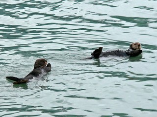
Sea Otters rolling and clapping beside the boat.
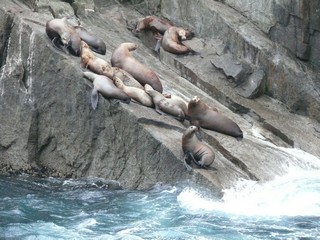
Sea Lions waddling and flopping on the rugged rocky islands.
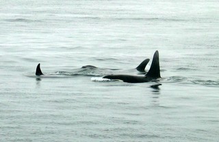
Orca whales – many of them.
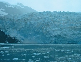
A glacier with it’s terminus in the ocean. These are the ones that “calve” and you can see the splash (on the left side) when a large piece fell off or “calved” while we were there.
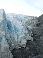
Next morning, before we pulled out of the campground, we visited Exit Glacier which is one of the fingers of the Harding Icefield. This glacier advances on land so has no “calving” associated with it. We were able to walk right up to the front edge of it. The melt water flows into the Resurrection River which then empties into Resurrection Bay right in Seward. Exit glacier has been retreating steadily – it is melting faster than there is snow to maintain it.
All in all, despite the weather a very satisfying time in Seward. We would certainly go back there again.
It’s only a little over 200 km from Seward to Ninilchick which is on the west side of the Kenai peninsula. Ninilchick is about 20 miles north of Homer, but as this was the 4th of July weekend, it was the only cam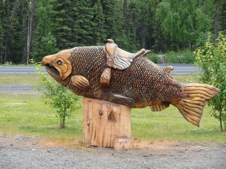 pground site available.
The west side is rolling and green and does not have the mountains “in your face” as the east side does. They are visible however, to the west across Cook Inlet.
We had seen a number of places advertising “chainsaw sculpture” and stopped at one such location. This fish was a masterpiece.
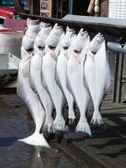
The west side of the Kenai concentrates on fishing – both commercial and tourist. Halibut is the major fish in this area and we saw some interesting catches as the charter boats came in. The big one on the left was over 4 feet long.
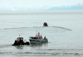 We watched a number of private fishing boats being launched. We had never seen it before, where a tractor hooked up to a boat trailer, drove right out into the water until the tires were almost submerged. The boat then was floating and moved away from the trailer. It appeared that the water was so shallow for a such a distance that normal boat launch, as we know it, was not possible. The procedure was reversed when the boat returned.
Homer is very much a tourist town and there is a long spit of land that runs way out into Kachemak Bay with many trendy and tourist shops and RV parks along its length. We spent most of one day wandering along the spit and also visited a couple of galleries in the town itself.
After those few days in the Kenai we headed to the north again on our way to Denali 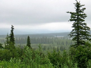 National Park. Alaska is a big state and we took 2 days to get to the park. We had read and been told that it is claimed that the drive as we approached Denali was one of the best in the state. Unfortunately, it rained and the ceiling was so low that we had no vistas at all ,so we can’t comment on that claim. We were however, close to the tree line and had some interesting views of the scruffy black pines that grow in the poor soil.
We arrived at Denali National Park and Preserve on July 8th and will continue the journal from there.
Posted by Bernice at 10:04 PM | Comments (4)