« May 2008 | Main | July 2008 »
June 26, 2008
Dawson City and the Top of the World Highway
 On Aug. 16, 1896, one of the world’s most fabulous gold strikes was made on Bonanza Creek, which flows into the Klondike River, just outside Dawson City, Yukon. The next summer miners from there arrived in Seattle and San Francisco with about $2 million in gold and set off a massive gold rush. By the summer of 1898, 30,000 inhabitants were in Dawson City making it the largest city west of Winnipeg and north of San Francisco.
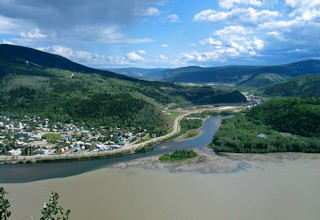
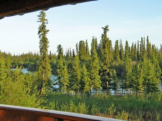
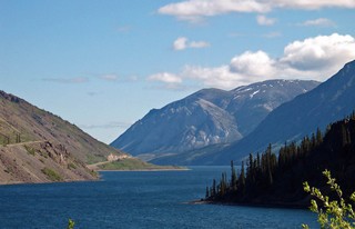
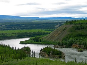
This picture is where the clear Klondike River flows into the muddy Yukon River. The Yukon River is a major river of the north – 3,185 km. It rises in the Coast Mountains in British Columbia and flows northwest through Whitehorse and Dawson City in the Yukon. After crossing into Alaska, it follows in a westward arc to the Bering Sea.
Times have changed; there is still some mining but the “rush” has gone, tourism is now a major factor in the town’s economy and the year round population has dropped to about 1,750.
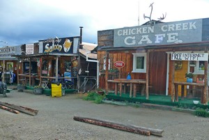
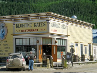 The town has character! There are a number of historic buildings, many still in use like Klondike Kate’s. Others such as the Post Office are open for tours (which we took).
A former co-worker, Sandy, moved to Dawson in 1990 and is now the manager of “Jimmy's” a video and more store. We spent a couple of evenings with her and found out that she has no intention of leaving Dawson. Typical of many residents, once they are there they don’t want to leave for the “outside”. Her job is all year round but many of the businesses close for the winter. There are only two small hotels that stay open in the winter and they take monthly turns so everyone can enjoy a holiday.
One evening we took in the show at Diamond Tooth Gertie’s Casino and I left my usual contribution to the local economy. It’s the only casino in the Yukon so I had to try! Another evening we visited Robert Service’s cabin and were treated to readings of his poetry. We drove up to Midnight Dome, a rounded peak above the city that gives panoramic views of the town, the rivers and mountains
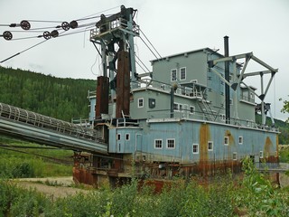
We also tried gold panning in Bonanza Creek – no luck, and then visited Dredge #4, the largest bucket-line, wooden-hulled dredge in North America. It’s four stories high and moved by digging the ponds that let them float and move across the area to be mined. The continuous line of buckets scraped the mud and rock and carried it to a screening areas that separated the gold (which is heavier). The waste rock, or tailings were then deposited out the back.
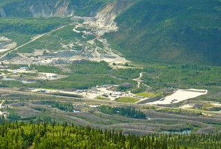
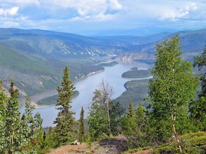
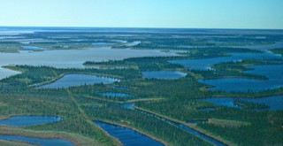
This picture was taken from Midnight Dome looking down on the tailings that were produced by the dredges on the Klondike River. You can see them in the lower foreground. They look like giant worms winding their way along the river. In the background you can see where there is still mining going on.
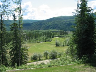
We had good weather while we were in Dawson and played golf at “Top of the World” Golf Course. We played in the afternoon on June 20th and that night they were having a tournament with a shotgun tee off at midnight. That far north on the summer solstice, it’s still daylight at midnight and actually stays light enough to play golf all night.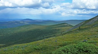
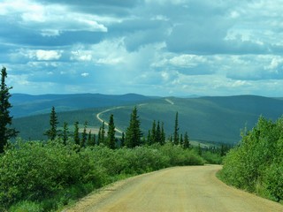
We crossed the Yukon River on a ferry that was just big enough to take our rig and four cars. There was then a steep 7 mile uphill pull that took us to the Yukon’s “Top of the World”. This highway runs along the top ridge of these mountains for100 km to the Alaska border and is only paved in sections, but at least the gravel is quite level and the road is acceptable.
From there the U.S. Taylor Highway drops down in a series of steep curves, pot holes and washboard and doesn’t seem to have had much maintenance this season or this section. From here on it was paved and generally OK.
The small hamlet of Chicken, about 70 km from the border, had wanted to have the name Ptarmigan, but couldn’t agree on how to spell it so settled for Chicken.
About 10 km before arriving in Chicken we encountered our first mechanical problem. The truck lost power and wouldn’t pull the trailer. We were at the side of the road and wondered what we would do. Bev & Ron were with us and figured that they could continue to Chicken and see what might be available there. We decided to try starting the truck again and it ran OK so we continued to the RV park.
The next morning, June 23rd, Bev & Ron headed out before us toward Tok so that Ron could do some fishing. We pulled out and all was fine – for about 300 yards – then we lost power again. The owner of the RV park towed us – truck & trailer – to a campsite. We unhitched and again the truck was OK. We decided to try the drive to Tok to a garage there to have the truck looked at. About 15 km down the road, we lost power again, limped along for about 40 km and stopped for a break at a rest area. When we started up to continue, the truck worked fine again. Longer story short – the garage in Tok finally found a module that one side was not locked down. This was reseated and locked and after later putting dielectric one the contacts everything has worked since then. Our best guess is that the severe shaking on the Taylor highway caused the unseating of the module. We spent an extra night in Chicken when we went back for the trailer, but other than the extra trip to Tok of 125 km each way, no major harm done.
From here we are aiming for Anchorage.
Bernie & Ross
Posted by Bernice at 11:37 PM | Comments (6)
June 22, 2008
Dempster Highway
From the time we began planning our trip to the north-west, we heard about the Dempster Highway, (the only highway in Canada that crosses the Arctic Circle, it took 20 years to build) in the Yukon/Northwest Territories and it has always been our plan to drive it. Beginning at the Klondike Highway about 40 KM (25 miles) east of Dawson City, extending 750 KM (450 miles) north to Inuvik (in-OO-vik), the all-gravel Dempster turned out to be everything we had heard and more. Inuvik is the focal point of the western Arctic, with a population of 3,300, of which a large percentage are First Nation Gwich‘in Indians. But I’m getting ahead of myself.
After many opinions we received about driving this highway, we decided to leave our 5th wheel at Dempster Corners and take only the truck. After crossing the Klondike River, for the first 100 KM’s we drove through flat scrub bush of black spruce, tamarack and aspen. Our first stop was at the interpretive centre at Tombstone Territorial Park. Although quite small it contained a full series of displays with emphasis on northern animals (a new centre about 4,000 sq. ft. is nearing completion and the staff is very excited about it).
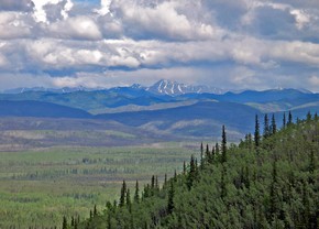
 Shortly after, we entered the Ogilvie Mountains and WOW! The most obvious feature of the far north is its size. It’s huge up there with vistas that spread out for miles in every direction. One of the things Bernie and I have talked most about is how to convey this sheer hugeness to you. Photos are two dimensional and it’s very hard to capture the space.
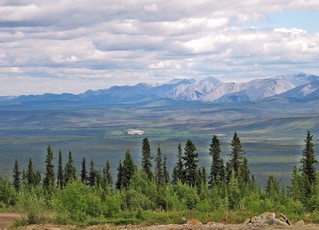
A second feature of the space is the emptiness. There is often nothing (except the spectacular views and animals) for hundreds of kilometres in any direction – no sideroads, utility poles, buildings, people, services – NOTHING - but around every corner is another breathtaking view. If we had been paid a dime for every time we said WOW, it might have paid for our fuel.
Our first night’s stop was at Eagle Plains, half-way north, at 345 KM; a kind of northern oasis for travellers - motel, restaurant (great food), lounge, fuel, repairs and tires, gift shop and more. They generate their own electricity with a diesel generator.
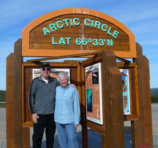
Shortly after leaving the next morning, we (Ron and Beverly, Bernie and I) arrived at the Arctic Circle.
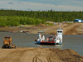 After photos all round, we continued north to Fort McPherson, then Tsiigehtchic and then the Mackenzie River crossing (our second location – the first was on the way to Yellowknife). The river is wider and deeper here, with many tributaries having fed into it over hundreds of kilometres. There are no ferry docks up here. The ferry pulls into the shore and drops a steel ramp on to the dirt and you drive on or off. The bulldozer at the shore extends the ramp to account for the river level drop as the snow melt slows. Next spring, the early rampaging river will wash out the dirt ramp from this year and they start all over again. In winter the river is crossed on the ice.

We travelled through the Richardson Mountains and again spectacular panoramic views. No, we never get tired of them.
The Richardsons were completely different than the Ogilvies the day before.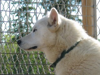 We arrived in Inuvik (celebrating its 50th birthday this year) the afternoon of our second day, June 13th, at Arctic Chalets, a B&B with a difference. They breed and work about 25 sled dogs – all are white with blue eyes (very rare) and very friendly. This up-to-date community has 3 supermarkets, a hospital, numerous hotels and restaurants, primary and secondary schools plus a college, as well as the usual assortment of smaller stores and services. The visitor centre was among the best we have encountered thus far. We had dinner our first night at the Chinese/Pizza/Burgers place on the main street. The next couple of days we spent sightseeing.
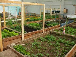
One of the most interesting spots was our visit to the old arena which has been converted into a greenhouse. Four by eight foot garden plots are rented and each family plants and decorates their space as they see fit. Most included vegetables (fresh vegetables are about twice the cost we are used to) and flowers. Because of the short growing season, few plants have time to mature outside. There is a waiting list for plots.
 This is truly the ‘Land of the Midnight Sun’ and one store was selling t-shirts that read in part “Sunrise May 26th – Sunset July 19th. We found it quite disconcerting that at bedtime it was fully daylight (like noon) and if you got up in the night it was still full daylight.
This picture was taken just before midnight on June 15th from the veranda of our cabin.
 On Sunday we flew to Tuktoyaktuk (Tuk for short) with ten others for a 2 hour tour of this Inuvaluit community on the Beaufort Sea (Arctic Ocean). The flight was at about 500 feet so we could see the Mackenzie Delta, one of the largest in river deltas in the world. Our guide -Boogie- is a lifelong resident and still maintains a traditional hunting/fishing/trapping lifestyle, including a 350 mile winter trap-line which he works with both snowmobile and dog team.
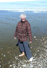 Bernie, in her winter coat, dipped her toes in the Arctic Ocean and was surprised how warm the water was, despite the fact that there was still ice not far off shore.
Much of the far north is built on permafrost – a combination of dirt and water – only a few feet below the surface which never thaws. But it must be kept frozen or whatever is above sinks, so all buildings are built on pilings with airspace under the floor so no heat is transferred into the ground. The Dempster highway was never less than about 8 feet deep of fill so the heat from the cars and the sun does not thaw the permafrost base. We wondered how many million truckloads of gravel were required to build this long road, which is never actually on the ground.
After 3 days of wonderful sights and new experiences, we began our trip back south stopping again at Eagle Plains for the night.
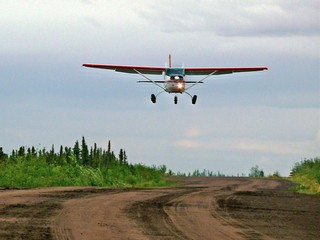 There are 5 airstrips along the way, all on or part of the highway. A sign says “Airstrip – DO NOT STOP OR PARK”. There are orange placards where they start and stop and orange cones along the edge. On our way back south, we were flagged down by four men and asked to block the road from traffic (there was none) while they took off. We saw another plane parked just north of Eagle Plains and a helicopter further south. There are barrels of fuel beside the airstrips.
They were treating the road with anti-dust chemicals and our white truck was dark brown, then it rained and it was brown with white zebra stripes. When we arrived back at Dempster Junction quite a few quarters went into the power washer at the park.
The drive was amazing and well worth going the extra mile (actually 900 miles). Bernie is working on our next segment about Dawson City and the Top of the World highway.
Stay tuned.
Posted by Bernice at 10:44 AM | Comments (8)
June 17, 2008
Yellowknife, NWT to Dempster Corners, YK
A couple of note-worthy sightings as we headed back on our long detour:
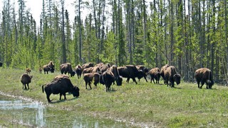
The Highway from Yellowknife borders the Mackenzie Buffalo Preserve and on our return trip we saw close to 200 animals – one herd we counted 67 adults and 7 calves. We waited about 15 minutes for the herd to cross the road. 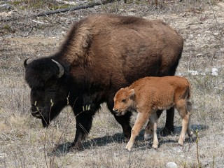
The babies were so cute and stayed right beside the Moms.
We have now travelled the full length of the Mackenzie Highway which begins in Grimshaw, Alberta and ends in Yellowknife, Northwest Territories.
We headed west from Grimshaw and arrived in Dawson Creek, British Columbia mid day on May 30th, 2008.
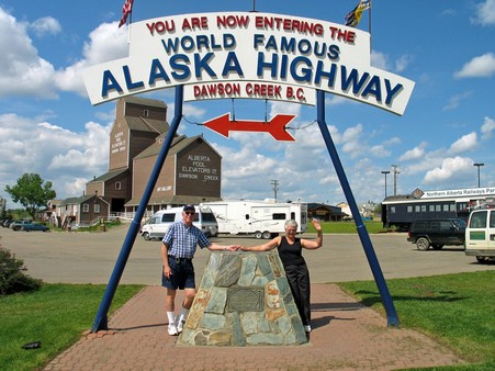
A sign at the obelisk reads:
At this spot in the spring of 1942 at the height of World War 2 the US Army engineers began the construction of the overland route to Alaska. Nine months later at a cost of over $140,000,000 the road was completed. This is a road construction feat unsurpassed in modern times. 11,000 troops & 16,000 civilians were employed in this project.
There are 133 bridges & 8,000 culverts embodied in the 1523 miles of gravel highway. The rattle and roar of the mighty bulldozers was a source of amazement to both the local white man and the northern Indian.
Over this lifeline to the Northwest, thousands of troops, food & war supplies have been transported, in more recent times the mighty H bomb was known to travel this route. It was maintained by the Canadian Army until April 1964; maintenance was then taken over by the Dept. of Public Works, Ottawa.
Having now travelled many miles of this road, we are absolutely astounded that it was built in the time frame that they did it.
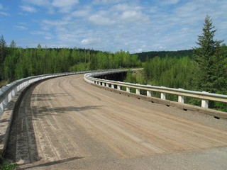 The current highway bears no resemblance to the original road. It is now pavement the whole way with gas and other services at regular intervals. The original was a mud track to move military supplies. The road then immediately began continuous upgrades. It has been straightened and flattened, bridges have been built to replace ferries and the road base has been totally overhauled. It’s a long road but no longer the endurance trip it once was.
We took a side trip to travel about 4 miles of the original road. This curved bridge with its plank surface is unique.
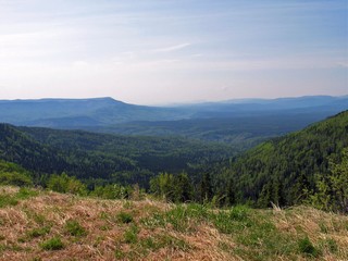
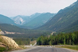
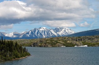
Our second day as we travelled from Fort Nelson toward Muncho Lake, the vistas were beautiful.
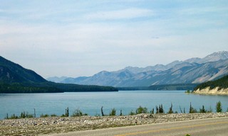
We stayed at Northern Rockies Lodge & RV Park on Muncho Lake. It was expensive – $35.50 for water and 15 amp power – and the sites were marginal. However, they are in the middle of nowhere, they make all their own power by generator and they have a captive clientele. So what did we expect?
The lake was a beautiful blue green.
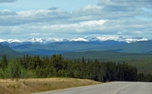
After stopping the next morning for a swim at Liard Hot Springs Provincial Park (I hoped it was the fountain of youth – but no such luck) we continued toward Watson Lake through some very rugged terrain.
There have been some steep hills and some long ones but seldom both steep and long. We travel mainly the river valleys.
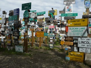 Watson Lake, in the Yukon, was first settled by a trapper in 1898 but now is most famous for its signpost forest that sits right beside the highway and the Visitor’s Centre. It was started by a homesick soldier in 1942 during construction of the Alaska Hwy.
In talking to the staff at the Visitor’s Centre, we found out that there are now over 65,000 signs posted there.
Our travelling partners, Bev & Ron, had brought a sign with them so there was one more by the time we left.
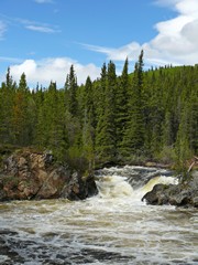
Waterfalls & mountains between Watson Lake & Teslin
Bev & Ron had never been to Skagway and travelling by highway to it is totally different than as we saw it on the cruise in 2005. We decided to stay a couple of nights in Carcross, YK and drive the 100 km down there with just the truck. One of the problems with pulling the trailer on mountain roads, is that the driver doesn’t have much of an opportunity to check out the scenery. Sometimes, it’s nice just to take the truck.
This is a bit of what we saw on our trip to Skagway.
We arrived in Whitehorse, YK on Sat. June the 8th and spent 3 nights there. It’s a thriving community of about 24,000 people. The population of the whole of the Yukon Territory is only around 30,000. It began during the Kondike gold rush and was the terminus of the White Pass and Yukon Route railway. Sternwheelers travelled from Whitehorse on to Dawson City. It was also a major construction location during the building of the Alcan (Alaska) Highway.
Whitehorse is named after the historic rapids on the Yukon river which resembled the flowing manes of charging white horses.
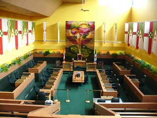 As of 1953 it became the capital of the Yukon Territory and as is our practice, we visited the Legislature.
The regular tour guide was off sick and our “substitute” tour guide turned out to be the Clerk of the Legislature so we had a very informative and insightful visit.
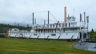
We took a tour of the S.S. Klondike, a restored stern-wheeler that plyed the Yukon River. It was one of the largest ships to travel the route and ran from 1937 to 55.
At the Beringia Interpretive Centre we learned about the ancient sub-continent of Beringia, an area of the Yukon, Alaska and Siberia never covered by glaciers during the last ice age. The water trapped in the ice that covered the rest of North America, caused the ocean levels to drop, exposing the ocean floor between Alaska and Russia. It is believed that this is the route travelled by the first people to enter America from Asia. This ancient area was populated by wooly mammoths, scimitar cats and giant beavers among others.
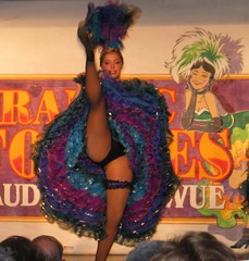 We had a fun night out at the “Frantic Follies”, a Gay ‘90s vaudeville revue.
They also included an excellent performance of the Robert Service poem “The Cremation of Sam McGee”.
We left Whitehorse on June 10th and about 12 km outside the city, we turned north on the Klondike Highway. We’ll come back to this corner on the Alaska Highway on our way out of the north. We travelled quite steadily, stopping for the night at Pelly Crossing and arriving in Dempster Corners, 490 km from Whitehorse and 40 km from Dawson City, the following day.
We stayed at the campground at Dempster Corners, left our trailer in their back lot for 5 days and took only the truck up the Dempster Highway to Inuvik.
That’s the next journal.
Bernie & Ross
Posted by Bernice at 07:33 PM | Comments (4)