« August 2008 | Main | October 2008 »
September 29, 2008
Montana - 2008
From Glacier National Park our route was down the western side of Montana to Missoula. In 2005 we had visited the eastern part of the state so we decided to see the west and west-central areas this trip.
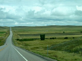
 We were still in view of the mountains although they were more at a distance and the road travelled through cultivated flat areas for the most part.
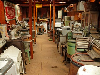
We did stop for a quick visit to The Miracle of America Museum. It includes autos, motorcycles, bicycles, trains, tractors, dolls, musical instruments and sheet music as well as washing machines seen here. I could go on listing more, as I don’t think there is anything made, that isn’t collected – right down to potatoe mashers. Started by a couple in 1981 it now has over 100,000 items as well as a pioneer village and the Montana State Fiddlers Hall of Fame.
Our plan was to spend only a couple of nights in Missoula, but things happen sometimes to change plans.
The second morning, as we were getting ready to pack up, the power in the trailer went off. I went out to check the utility post and as I came back in, Ross told me to quickly go back and unplug the trailer as there was an electrical burning smell. When I opened the door to the basement (the under storage area) smoke billowed out.
Long story short, with assistance from another Hitchhiker owner (thanks so much Bob) it was determined that the utility post was sparodically registering 220 volts, rather than the 110 it should be, and the high voltage had “fried” our AC power management system. We then reported to the campground office what we felt had happened, but as it was now Friday afternoon, they couldn’t get anyone out to check the problem until Monday. They said that they had had work done on the system in April – but this was Sept. We tried to find a new inverter in Missoula, but no luck– closest one was in Oregon and it was over $2,000. No other solution to our AC problem was available in Missoula.
Our solar system was still charging the batteries, so we did have 12 volt power and we had switched the refrigerator and the water heater to propane. As it was now late in the afternoon, we ended up staying another night.
 The next morning, Saturday, Sept. 13th, we hooked up and went east to Great Falls, MT. The land is big and rolling and we could see the “Big Sky” that is Montana’s slogan.
We wondered if we would ever hear from the campground about our electrical problem now that we had moved on, but they had seemed to be concerned.
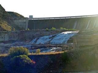 The Great Falls of the Missouri River was first seen by the Lewis & Clark expedition in 1805 when they had to portage 19 miles around a series of five waterfalls. Today the dam right above the Great Falls has reduced that one to a trickle. There are 5 dams producing electricity on the river and one of the falls has been flooded. I think we were a bit disappointed.
But we weren’t disappointed with the Lewis & Clark Historic Trail Interpretive Center.
It deals with the 1804–06 expedition, particularly as it relates to Montana. It also highlights the Indian tribes who aided them on the journey. It’s situated on the Missouri river and features walking trails and landscaped grounds. An excellent stop.
On Monday morning, after having done research on the internet, we ordered a replacement Xantrex inverter (for $1,400) which had to come from New Jersey by overnight express to arrive on Tuesday. We made arrangements with a mobile RV service to install it when it arrived.
 Meanwhile, that afternoon we visited the Charles M. Russell Museum, home and Log Studio. Russell, born in 1864, was an artist of the American West who created more than 2,000 painting of Indians, cowboys and landscapes. He also produced bronze sculptures, was a writer and a storyteller. As you can guess, no pictures of the paintings were allowed in the museum..
He actually was a ranch hand from the age of 16, so his work is wonderfully realistic. His largest (12–by-25–foot) painting “Lewis & Clark meeting Indians at Ross’s Hole” was commissioned for the State Capitol in Helena. In order to create that painting, his studio including the fireplace, had to be raised about 6 logs.
Tuesday, Sept 16th, the Inverter from New Jersey, arrived early afternoon and the technician installed it. Unfortunately, although we now had AC power when plugged in, we found that a very specialized fuse was also blown and we could not invert – that is, produce AC power- when unplugged. Couldn’t find one anywhere in Montana and had to have it overnight expressed to us from Oregon. It arrived on Wed. morning and our service man came back, installed it and by about noon on Wed. the 17th, close to $2,000 later, we were finally back in business and on our way again.
But that isn’t all the story. On Monday afternoon, we had received a call from the Missoula campground advising that the electrical contractor had been out and had determined that there was a manufacturer’s fault in the power box at our site. We then contacted the contractor and were advised to get everything fixed, being sure there wasn’t any other damage and send them the bills. We did that and within days the cheque was in the mail to us.
It would have been so easy on their part to deny liability as we had already moved on and weren’t there to check what they found. Thank goodness, the campground and the electrical contractor were both honest and honourable.
As we usually do, we stopped for a few days in the capital of the state - Helena. The pronunciation is HEL-e-na, as any other way was considered too feminine. The city was founded as a gold camp in 1864 and became the capital of the territory in 1875.
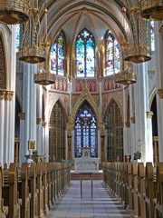
We visited the Cathedral of St. Helena which is modelled after a church in Vienna. An elegant building.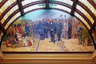 We did visit the Capitol which was completed in 1902, built of Montana granite topped by a dome of Montana copper. Here we saw the C.M. Russell painting spoken of earlier.
We had an excellent tour guide and one of the many facts stood out: Montana still has not reached a population of 1,000,000 but at any given time there are 2,500,000 to 3,000,000 cattle in the state.
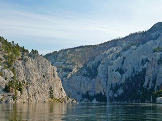 Our last full day in the Helena area, we went back north to The Gates of the Mountains Recreation Area, and took a narrated boat tour on the Missouri River, through the narrow canyon. The limestone walls tower 1,200 feet above the river as it cuts through the Big Belt Range. Lewis and Clark named the canyon in 1805 while on their Expedition.
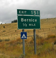
We next travelled south and slightly west on Interstate 15 to Butte, MT. On the way we passed an exit to the community of Bernice. Didn’t know that one existed.
Butte is another community built on mineral wealth; first gold and silver but finally copper made the communitie’s reputation as “the richest hill on Earth”. In it’s hey-day in the late 1910s and early 1920s it had a population of 100,000. Eleven (11) billion – yes, that’s a “b” – pounds of the metal were produced.
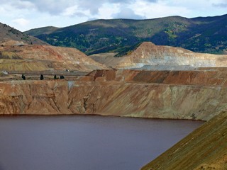
Then in 1955 the Berkeley Open Pit Mine was started and was one of the larger truck-operated mines in the world. It’s 7,000’ long, 5,600’ wide and 1820’ deep and now is filled with water about 1,000 ft deep. Unfortunately, the water is so acidic that it can not be reprocessed for any use.
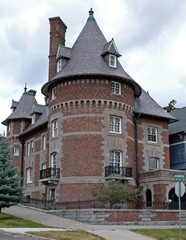 Butte is a city in the past. The historic district covers a very large area and has a huge concentration of around 4,000 late 19th-and early 20th-century residential and commercial buildings. The whole downtown has been named a National Historic Landmark. We did see a few that have been maintained and restored but relatively few are in good repair and many are abandoned. There are also mining relics, steel head-frames and other artifacts that speak to the 2,000 miles of tunnels under “the hill”.
 We visited “Hell Roaring Gulch and the World Museum of Mining”. It’s a 50 building, reconstructed 1890’s mining town, on the grounds of Orphan Girl mine, which still contains the original head-frame, hoist and hose house.
Montana’s casinos are interesting. They are everywhere, but they are small. The maximum number of machines is 20 and all are poker or keno – no slots. Only on a couple of Native Reservations are more machines and slots allowed and that was only a little over 100.
We did some shopping, I visited a casino and we were on our way again to Dillon, MT. about 65 miles south.
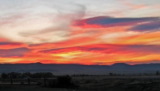
Our campground was south of Dillon and set in the wide open spaces of Montana. The nearest neighbours to the campground were herds of antelope and we had some beautiful sunsets.
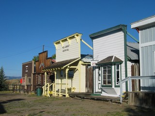
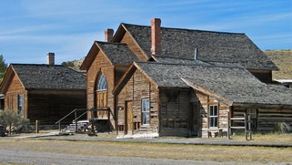 Bannack State Park was about 35 km west of the campground. It is one of the best ghost towns and is preserved and protected rather than restored. Another community founded on gold – in 1862 – and deserted when the gold ran out. It was the first territorial capital and had among other firsts in the state, the first jail, hotel, Masonic Lodge and commercial sawmill. A very realistic and interesting visit, as we could wander in and out of the over 50 buildings still there – all frozen in time.
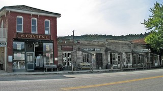 The following day, Wed. Sept. 24th, we travelled to Virginia City. Totally different than Bannack. This town is commercialized and although more than 130 early buildings have been preserved it doesn’t have the same feel as Bannack. That may be because it still exists as a town even up to today, where Bannack was basically deserted after 2 years, when gold was found in Virginia City and the miners flocked there. Unfortunately, we were there too late as many of the businesses had closed for the season on Labour Day.
Montana had been eventful and interesting and we had spent about 3 weeks seeing the sights. We made arrangements to fly home, on Sept. 30th, from Salt Lake, Utah for a couple of weeks. As we had visited central Idaho when we were west in 2005, we didn’t plan on much time in that state. However, time to move further south.
Posted by Bernice at 11:51 PM | Comments (6)
September 15, 2008
Waterton Glacier International Peace Park
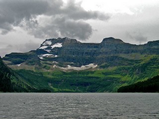
Our final Canadian and first US stop on this part of the trip was a visit to Waterton Glacier International Peace Park, in south-west Alberta and northern Montana, founded in 1932 as the world’s first international peace park. The combined parks encompass more than 1800 square miles and have more than 700 miles of hiking trails and wilderness camping. The Waterton section in Canada enjoys two UNESCO designations – a World Heritage Site and a Biosphere Reserve. We spent 2 days exploring the town site and roads in and around the park. The town is a miniature version of Jasper or Banff, providing the essentials of food, fuel and accommodation but with less choices, plus outdoor outfitters and tourist services such as boat rides, guided hikes and nature walks.
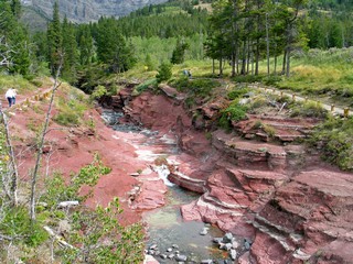
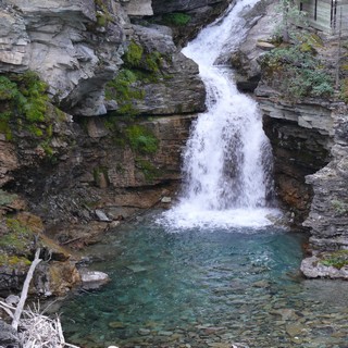
Red Rock Canyon is a spectacular walk around very unique rock formations, and yes you guessed it, they’re red, very red. The trail is kind of a figure eight loop, first to Blakiston Falls and then around the canyon itself.
Our second day we drove to Cameron Lake and walked briefly around the area, but it was cold and the season was winding down so there was little activity.
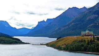 One of the most famous photographs of this Canadian jewel of our national park system is of the Prince of Wales Hotel, which is sited high above Waterton Lake and looks south down its entire length. Naturally, like all the other visitors, we took our photo as well.
On Saturday, Sept 6th, we travelled south from Alberta (the Waterton section), to West Glacier in Montana. Bernie managed to pick a route beside yet another rail line, this time the BNSF mainline. After setting up at the RV park and a little grocery shopping, we visited the US National Park Visitor Centre to plan our trip inside the park.
If you’ve been following along with our trip this year (and we hope you have), you’ve probably realized this is our year of great drives – the Alaska Highway, the Dempster, Top of the World, Denali Park Road, Klondike Highway, the Richardson, Yellowhead, and the Icefields Parkway – and then the Going-to-the-Sun Road, in Glacier National Park, the US section of the international peace park.
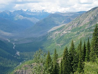 Most of our drives have been in a valley near the bottom of a mountain range but this one – 50 miles through the park – is along the edge, kind of halfway up the side. Most of the trip is 1 lane in each direction, but some of it is 1 lane total, while they are rebuilding several sections, the first such work in many years. This year is the 75th anniversary of the road opening.
Vehicles over 21 feet (including bumpers) and 8 feet wide (including outside mirrors) are prohibited, due to the many sharp turns along the route. The road skirts the edge of lakes, McDonald at the west end and Saint Mary at the east end, near the town of the same name and crosses over Logan Summit, elevation 6,646 feet (2,025 metres), a rise of over 3,500 feet from West Glacier.
 The NP ranger suggested we allow 3 hours for the drive – about 16 miles an hour – and he was close. It only took us about 6 hours plus the 2 hour return to the RV park on the regular highway. We’ve lost track of the number of short hikes and photo stops we made, but as you can guess, there were lots of them.
The first was a 1 mile boardwalk hike on the Trail of the Cedars nature trail, a protected original growth cedar forest, with some trees estimated to be over 500 years old.
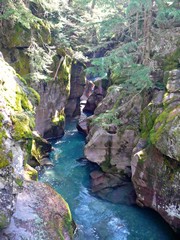
Other spots included Avalanche Creek, (a narrow gorge through red mudstone– picture to left) Packers Roost, Triple Arches and the unique Garden Wall, believed to have been formed by 2 glaciers scraping both sides of the top of the Continental Divide until there was only a thin wall of rock remaining. Of the many mountain ranges we have seen on this trip, it was indeed one of the most unusual features. Unfortunately, no good picture stopping area that would show the narrow ridge.
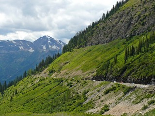
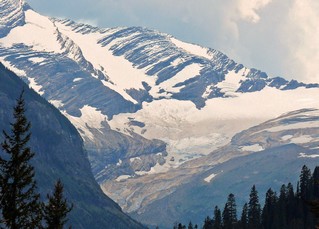 As we travelled we were surrounded by mountains of 8,800 to 10,000 feet, including the Going-to-the-Sun Mountain at 9,642 feet (2, 939 metres), near the Jackson Glacier Overlook. Several were still snow covered even though it was the first week of September.
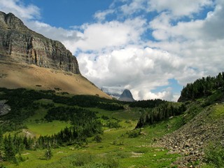
Along with hundreds of other tourists, we visited the Logan Summit (6,646 ft) Visitor Centre for a bathroom break and more photos of the spectacular scenery. There are a number of hikes that can be taken from here and this is the view from part way out on one of them.
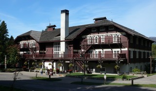
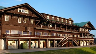 On the highway on the way back, we stopped to check out the world famous Glacier Park Lodge. The lodge and other out buildings are built with logs (many of the structural ones are 3 feet in diameter).
It was built by the Great Northern Railroad about a hundred years ago and is still a special stop on Amtrak’s Empire Builder route. Luckily for me, the train had just arrived and there was lots of activity. 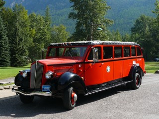
The train is met by red limousines built by Ford in 1938. These special vehicles, with a capacity for 16 people, have a convertible top and are used for sightseeing in both parks. A few years ago they were refurbished keeping all the original design.
We arrived back at the RV about 8 PM after an outstanding day. As many times as we have said it, there is apparently a never-ending supply of “Wow’s” to be seen across this continent.
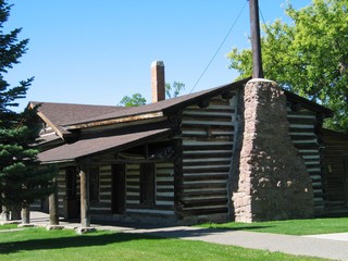
The next day, we returned to Lake McDonald to visit the log lodge there. Although not as big, it is about as old as Glacier Park and has much of the same appeal.
The following day, after a lazy morning we drove into Kalispell, the major community in this part of Montana, for a few supplies. On our way back we stopped to visit the dam that creates the Hungry Horse Reservoir. It’s one of the world’s largest concrete dams at 2,115 feet at the crest and has a 39 foot-wide roadway crossing it. Although all set up to provide information on the dam, we were too late, as everything was closed. Probably because we were there after the Labour Day weekend.
Wed. Sept. 10th, we hit the road for Missoula, Montana, the first of several stops in the western part of ‘Big Sky Country’ and we’ll write about them in our next chapter of this great road trip.
Ross & Bernie
Posted by Bernice at 11:38 PM | Comments (1)
September 10, 2008
Alberta again - Summer 2008
 In the middle of the night the mountain fell.
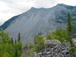
At 4:10 am on April 29, 1903 ninety million tons of limestone crashed from the summit of Turtle Mountain and buried part of the sleeping town of Frank, AB. 70 of the 100 people in the path of the slide were killed.
The rock mass that fell was 150 metres (500 feet) deep, 425 metres (1,400) high and 1km (3,280) wide and covered an area of 3 square kilometers (1.2 sq. miles)
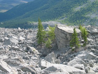 The rocks are huge and the debris field is eerie to wander through.
The primary cause of the Frank Slide was a combination of the mountain’s unstable geological structure, water action in cracks, underground coal mining and severe weather conditions.
Mind you, the First Nation residents of the area already called it “the mountain that moves” and wouldn’t camp at the base. They were smart!
The road today runs right through the debris field and the railroad also runs at its base. The mountain is still unstable and we learned that many sensors have been placed and are constantly monitored. The Interpretive Centre opened after extensive renovation, a few days after we visited.
The Municipality of Crowsnest Pass is made up of the former coal-mining towns of Bellevue, Blairmore, Coleman, Frank and Hillcrest and we spent another day visiting the various historic sites in these villages.
Wed. morning, August 27th. we headed east, still on Hwy 3. When we reached Hwy 22 about 20 km down the road, we turned north toward Calgary. 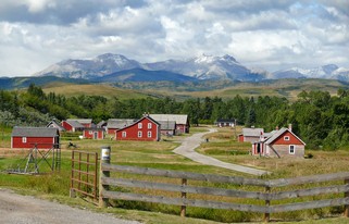
On our way up Hwy 22, we stopped at the Bar U Ranch, a National Historic Site. This ranch, founded in 1882, at it largest, encompassed 157,960 acres and reported 10,410 cattle and 832 horses.
The buildings are original, although some have been moved from outlying areas and the backdrop of the Rockies is beautiful.
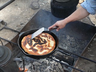
They had a “round -up camp” set up and we had our first taste of bannock. It’s an unleavened dough that is fried in fat in a heavy frying pan, over the open coals.
We had it served with both jam and a honey walnut spread.and it was very good.
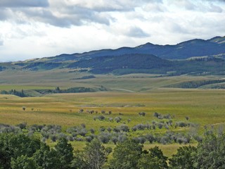
We have been travelling so long through mountains that it was quite a change (relief?) to come into the foothills and be able to see long vistas and generally flat roads.
A visit with my cousin and his wife, a visit to a dentist for an abscessed tooth, as well as taking the trailer in to the Hitchhicker dealer for some maintenance took a couple of days while we were in Calgary.
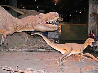
We visited the Royal Tyrrell Museum in Drumheller which is about 125 km (75 miles) north east of the city. Internationally recognized for its palaeontological research, extraordinary collections and dynamic galleries, it sets out the story of the evolution of earth and the golden age of dinosaurs. We had visited there many years ago – I think about 1987 – and found many new and much improved exhibits this time.
We returned to Calgary by a different route, driving south on the Hoodoo Trail about 16 km (10 miles) along the Red Deer River before heading cross country back to the city.
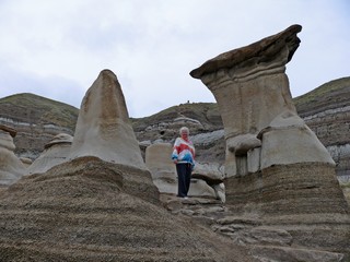
The strange sandstone formations called Hoodoos are found right beside the highway and there are trails through them that can be hiked. They are very fragile so no climbing.
Hoodoos are sandstone pillars resting on a thick base of shale that is capped by a large stone. The cap rock is very hard and protects the soft lower layers from erosion.
In the Blackfoot and Cree traditions, the Hoodoos come alive at night to hurl rocks at intruders.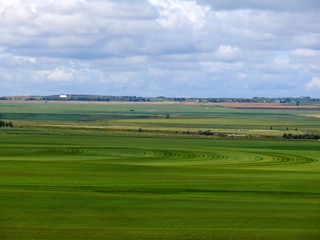
It was an easy drive south from Calgary on Hwy 2 and we travelled through beautiful flat rich aglicultural land (note the irrigation circles).
We stayed in Fort Macleod, as a base camp, for 3 nights, as we wanted to visit areas both east and west of the town, and it’s much easier taking only the truck.
After we set up at the campground, and it was early in the afternoon, we headed east to Lethbridge. The city was founded in 1870 and is an agricultural centre as the area reportedly receives more hours of sunshine annually than any other spot in Canada.
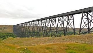 As most of you know, Ross has a penchant for trains, and things train. Lethbridge is the home to reputedly the longest and highest bridge of its type and construction in the world.
Built in 1909 it is 5,327 ft. (1,623 metres) in length (1 mile plus 47 feet).
It is still in use today.
Sept 2nd, our first full day in the area we went to Head-Smashed-In Buffalo Jump, a Provincial, National, and UNESCO World Heritage Site.
Native people stampeded bison over these cliffs, channeling them to the drop by cleverly placing rock and trees and directing the herd with waving arms, yelling and arrows. 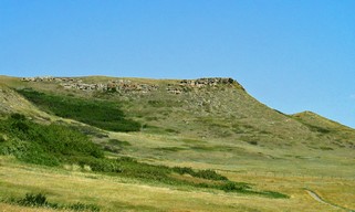 The buffalo provided them with food, clothing, tools and shelter, ensuring their survival.
The name comes from a young brave who wanted to witness the spectacle from under a ledge at the foot of the cliff. Unfortunately, his skull was crushed as he became trapped between the carcasses and the cliff.
The seven story interpretive center, built into the cliff, has displays focusing on geographical and climatic factors of the tribes. There are also short trails leading to the hunting site.
We continued further west, to return to the Frank Slide area, so we could visit the Interpretive Centre which had been closed earlier. It provides history about the area and the mining that took place there as well as the slide (of course). It was well worth the return visit.
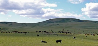
On our way there, we followed a gravel road for about 40 km. and saw some huge cattle herds.
Now, we’ve travelled a lot of miles on this trip on gravel roads and never had a mishap.
Yes, you guessed it. On this stretch of gravel a stone flew up from a truck we met and hit the windsheild. We ended up staying another day in Fort Macleod to get it replaced.
We left Fort Macleod on the morning of Sept 4th, with our destination somewhere close to Waterton-Glacier International Peace Park.
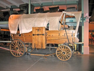 We only had about 100 km (62 miles) to travel, so we had lots of time to stop in Cardston, at the Remington Carriage Museum. It houses the largest collection of horse drawn vehicles in North America – 250 pieces of buggies, carriages, wagons and sleighs.
Started in 1954 as a private collection, Don Reminton donated his then 48 vehicles to the Province in 1987. Alberta built the beautiful museum and consolidated another 175 vehicles in the same place. Another excellent stop.
After lunch we finished our trip to the Waterton area and set up camp a bit outside the park.
Ross is writing about our visit to this National Park that is twinned with Glacier NP in the U.S.
Bernie & Ross
Posted by Bernice at 09:05 AM | Comments (3)