« January 2007 | Main | March 2007 »
February 28, 2007
Texas to Tucson 07
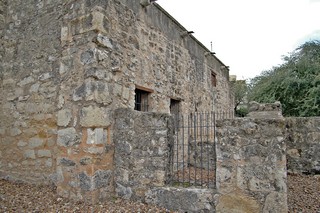
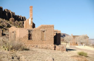 The original Fort Davis, established in 1854, was a strategic point on the San Antonio-El Paso Road. The soldiers first stationed there fought the Comanches on mules. The major work of the troops however, was to protect emigrants, freighters, mail coaches and travellers. The post was rebuilt in 1869 and is said to be one of the best remaining examples of a frontier military post.
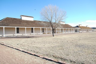
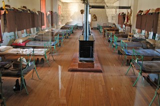
A number of the buildings have been restored and much of the original structural was able to be used. Other buildings have been stabalized to prevent further deterioration but many are merely shells or foundations. A few buildings have been authentically furnished.
 “Buffalo Soldiers” served at Fort Davis from 1867 to 1885. According to some historians, these regiments of black soldiers were given the name by the Indians who compared their hair to that of the buffalo, and considered them brave and worthy adversaries.
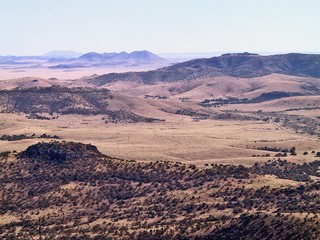
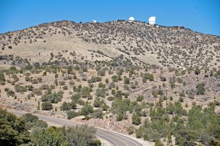 About 17 miles north west of Fort Davis is McDonald Observatory, one of the major astronomical research facilities in the world. It is on 6,791 ft Mount Locke and has several optical telescopes ranging in diameter from 30 to 432 inches.
The area has one of the darkest night time skies in the U.S. and the surrounding communities co-operate by using lighting that is directed toward the ground.
The view from the top is quite wonderful.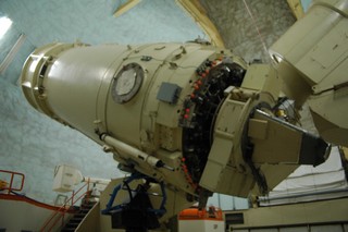
We took the guided tour and were taken right into the area housing the telescopes. Interestingly, seldom does anyone look though the eyepiece viewers. All the data is collected and transferred to computers elsewhere in the building. Apparently, the astronomers don’t even have to come here any more, they can just have the data sent to them via the Internet.
From Fort Davis we headed back south to Marfa.
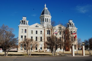
This is the Presidio County courthouse in Marfa. We were disappointed in the town – from what we had read it was described as an artist’s community. I guess it is if you are into new age and modern. Not my thing, so we spent little time there and headed toward El Paso.
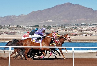
As we had spent a couple of days last winter in the El Paso area we only stopped long enough to leave our contribution at the racetrack casino. We parked right beside the track and Ross got a great action picture just after the horses came out of the starting gate.
Last year we had purchased a Raspberry Chipotle sauce in the old town of Mesilla, NM, just on the outskirts of Las Cruces. Best we have ever had. We stopped in old town again; told the proprietor we had driven 2,500 miles to get more; bought 6 bottles and she threw in a seventh for nothing.
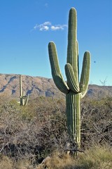
We arrived in Tucson Feb. 18th and spent a week there. My sister Joan, who lives in Fredericton, NB is spending a couple of months there, so we had some good visiting with her.
We went to the Saguaro National Park and took the circle drive. We visited with friends from Big Bend, Bob & Melissa. We took some time off, we played golf, we did laundry, and we did some gambling.
On Sunday Feb.25th we headed south to Mexico.
Next journal will be about our trip down there.
Posted by Bernice at 03:45 PM | Comments (2)
February 25, 2007
Big Bend National Park - Part II
 Just after lunch on Monday, Feb 12th we started on an approximate 50 mile loop road in the western part of the park. The first 13 miles (22 km) of the road was dirt and gravel. Since it had rained a couple of days earlier, there were still muddy sections to it and we could see deep ruts where other vehicles had trouble navigating. We were happy we had the high clearance of the truck. The land is stark and we passed badlands and cliffs and deep washes.
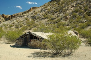 We stopped to see Luna’s Jacal (a primitive Mexican house-shelter). Gilberto Luna, a pioneer Mexican farmer, built this shelter and raised a large family here. He died in 1947 at the age of 108. Luna had farmed this dry Alamo Creek drainage for nearly a century and had peaceful relations with both the Apaches of the area and the Comanche War parties. The jacal at the peak is only about 4 feet high but is about 30 ft long.
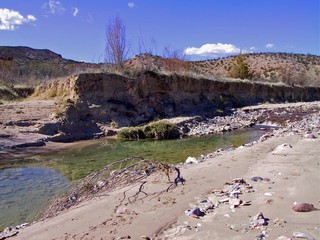 Close to the end of the gravel road we turned off and followed a dirt road to Terlingua Abajo, a deserted farming community. Finally, we found water other than the Rio Grande River. When quicksilver (Mercury) was discovered in 1899, much of the flatlands by the waterways were cleared for farms. This area produced vegetables, wheat and maize for the miners. Water was channelled to the fields by irrigation ditches. When the mines closed so went the farms.
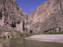
At the end of the gravel road we again reached the Rio Grande River. We crossed Terlingua Creek on stepping stones and headed 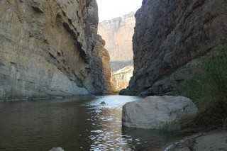 for Santa Elena Canyon which is spectacular! At its mouth the walls tower 1,500 ft. Mexico’s Chihuahua state forms the left wall and of course Texas is on the right. The 17 mile long Terlingua Fault is only accessible by canoe or for about 1/2 mile on a trail. This picture is at the end of the trail looking further into the canyon. The trail is steep and narrow in places but well worth the effort. The canyon was about 15F cooler than the flood plain just before the entrance.
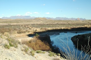
As we looked out over the flood plain from the entrance to Santa Elena Canyon there is little evidence of the fields that once covered this area. In 1914 the land was prepared for irrigated farming with ditches moving the water from the Rio Grande. Cotton was successfully grown here until 1974 when a flood carried the heavy ginning machinery to the bottom of the river.
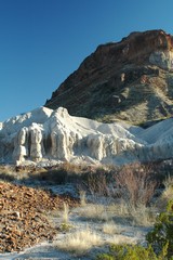
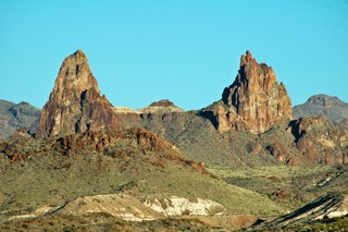
We headed north toward the centre of the park and came upon this white stone outcropping. It is called “tuff”and is actually compressed volcanic ash which has been cemented together by pressure from overlying layers and later exposed by erosion. A little further on are Mule Ears Peaks, again formed by erosion into the shape of mule’s ears. They have long been a traveller's landmark.
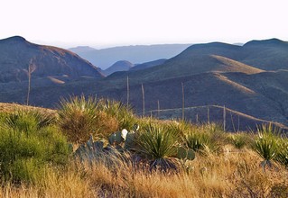
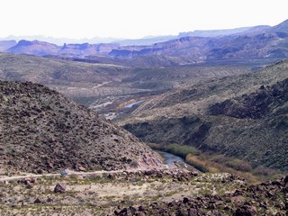
The sun was getting low when we reached Sotol Vista. From here we had a 360 degree view of the park and could see the Santa Elena Canyon 14 miles away, as the raven flies.
It was soooooo quiet up there. No traffic sounds, no trains, no people – just the wind as it blew through the grass and the sotol plants.
As we finished our day ,we drove along the west side of the Chicos Mountains and were able to look into the same window in the mountain that we had looked out of, from Chicos Basin at sunset, the end of the day before. Check out that picture again in the previous journal – Big Bend National Park – Part I.
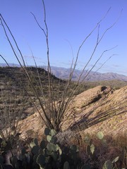
The next day we visited Big Bend State Park which is to the west of the National Park. Similar landscape as the national park and below are a few of the pictures we took there.
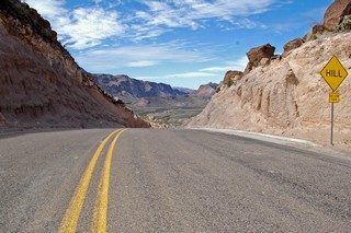
This “Hill” has a 15% grade for close to a mile.
At the top looking down.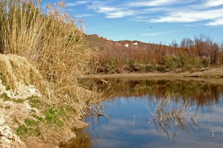
At times the Rio Grande is very beautiful.
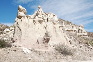
More “tuff”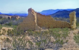
We ended our day with a visit to Terlingua Ghost Town which is now being repopulated by artists and crafts people who have resurrected some of the old buildings.
We remained in Terlingua one more day as the weather at our next destination, Fort Davis, Texas was for freezing temperatures and possibly snow. We went to the golf driving range and hit some balls into the desert. We didn’t play the course as it is a “target course”. You hit from the tee to a patch of grass, over the desert shrub and then hit from there to the green, again over desert scrub. We’re not good enough for that and I don’t think we could afford the lost balls.
Now on to Fort Davis.
Bernie & Ross
Posted by Bernice at 06:46 PM | Comments (5)
February 22, 2007
Big Bend National Park - Part I
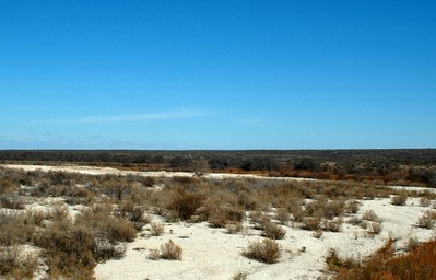 We left Mission Wed. Feb. 7th on a bright sunny day and headed north west following the Rio Grande River. The land changes from the cultivation of the lower valley to huge expanses of desert. This is not the desert of movie films with sand and sand dunes everywhere. Instead, it is a desert of higher elevations, vast expanses of creosotbushes and only 8 to 12 inches of rain in a year. As we travelled the land was flat, flat and flat, however as we reached the area of Big Bend National Park the mountains could be seen easily in all directions.
 We spent the second night after leaving Mission, in the town of Marathon, TX. which is considered to be the gateway to Big Bend. There is a very neat old hotel in town, “The Gage” which has been restored to its original look. It was opened in 1927 and is still an operating hotel with all the amenities. Although we didn’t stay at the hotel, the staff welcomed us to tour. The town itself is quite unassuming and has a number of excellent craft and gift shops. Of note, the gas was the most expensive we have had since leaving home in December – we paid $2.98 U.S./gallon – which translates into approximately $.96 Cdn/litre.
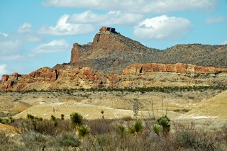
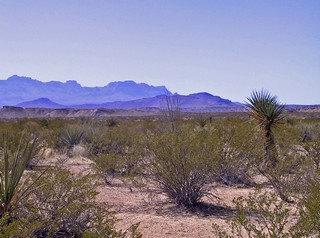 This is the view of some of the mountains of Big Bend as we headed south from Marathon. The park was named for the U shaped bend of the Rio Grande which borders the park. It wasn’t dedicated until 1944 and is the only national park in Texas. Mind you, its big, a little over 800,000 acres -but then, everything in Texas seems big. In summer, the temperature of the ground can reach 180 F and in winter can be freezing. While we were there it varied from mid 30’s at night to low 70’s during the day. We spent two days dry camping (that is not hooked up to any water, electricity or sewer) at Rio Grande Village Campground which is in the south east of the park. The “village” consists of a store and the campground. It was a wonderfully quiet park and at night the dark was truly dark and millions of stars could be seen.
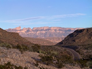
From height we could see the massive Sierra Del Carmen mountains across the Rio Grande in Mexico.
 In Boquillas Canyon, which cuts through the mountains, it would be easy to walk across the river to Mexico (we didn’t). Since 911, a number of smaller border crossings have been closed and this has been devastating to the small Mexican towns on the other side of the river. A few Mexican nationals wade across the river and set up to sell small crafts and walking sticks. There are warning signs that if you purchase from them, you can be arrested and fined. We met one such man in Boquillas Canyon and he was selling walking sticks for $4.00. We saw the same sticks in the park store for $18.00 and the manager said it was only this year that they had finally received permission to purchase them from the town across the river.
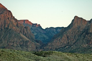
We moved from the east side of the park to a campground just outside the west gate and the next couple of days explored the west side and the Chisos Basin.
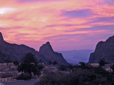
The Chisos Mountains are wholly contained in Big Bend National Park and in the centre of them is a natural basin that was developed with a lodge, cabins and a campground, in the late 30’s by the CCC (Civilian Conservation Corp). We had dinner at the lodge and were treated to a beautiful sunset through the “window” in the basin. Although there is a campground, trailers over 24 feet are not allowed into the Basin due to the steep roads and sharp curves descending into it..
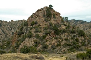 This pile of rock in the basin is called “Appetite Peak” and could be close to 100 ft. high. As the story goes, when one of the young men of the CCC complained about the food that was served while they were building the facilities in the basin, they were sent out to conquer this peak before they got to eat again. No more complaints!
That same night we went to the lecture put on by the park. Most of the parks have regular presentations and this one was on astronomy. We spent the hour after dark being guided through the heavens by a very knowledgeable park ranger.
The final couple of days were very full so I will do another journal to finish our visit to Big Bend.
Big Bend Part 2 coming soon.
Bernie & Ross
Posted by Bernice at 10:50 AM | Comments (0)
February 12, 2007
South Texas - Winter 2007
We arrived at Trader’s Village campground early in the afternoon of Christmas Eve. The campground is right beside a HUGE outdoor flea market. It was miserable weather – wet cold drizzle (about 45F (7C). We wandered around for a bit, watching hundreds of people doing their last minute shopping, before we headed back to the trailer and snuggled in all warm and cozy.
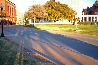 Christmas Day was still cold but the sun came out by noon. Since it was the holiday, we decided it would be an excellent time to head to downtown Dallas and visit the site of the Kennedy assassination. As you can see there was little traffic. The red building in the upper left is the Texas School Book Depository where Lee Harvey Oswald shot JFK from the 6th floor window. The X on the road on the right side is the location of JFK when he was hit. After having read and heard about this for years it was a very somber time to wander over the area.
We wanted to go out for a traditional turkey dinner, but had to change our plans. Don’t count on restaurants being open in the Dallas area on Christmas Day. We ended up at a Chinese Food Buffet which was very good – and they even had turkey, mashed potatoes and gravy.
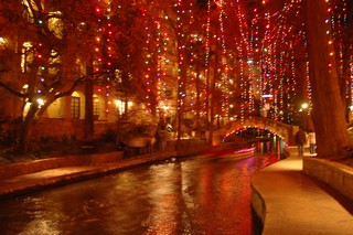
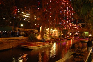
San Antonio is renowned for it’s Riverwalk and what a spot! From Nov 24th till New Year’s Day it is illuminated with 120,000 lights. We took one of the narrated river cruises which is probably the best way to see all the lights and learn about that area of the city. After that we wandered along the canal, sipping a coffee and enjoying the whole atmosphere.
 There is a neat area called Market Square which includes “ El Mercao” patterned after an authentic Mexican market, as well as a Farmer’s Market. From there we visited the Spanish Governor’s Palace which was built in 1722 and served as the home of the Governor of Tejas (Texas) during the Spanish Government period that ended in 1821.
Of course, when you are in San Antonio, it is a must to visit “The Alamo”. Originally a mission built in 1724, it is most famous for the 13 day defence against Santa Anna’s army in 1836 during the Texas Revolution. Among the Alamo’s garrison were Colonel William Travis, Jim Bowie and Davy Crockett. It is best remembered as a heroic struggle against overwhelming odds – about 200 defenders vs 4000 Spanish army troops
Deborah and George, friends from Edmonton. were flying down to South Padre Island for a vacation and we had arranged to meet them for New Year’s Eve. We left San Antonio with a promise to ourselves to come back again as there were a number of sights that we didn’t get time to visit.

We headed straight south on Hwy 281, over to 77 at Raymondville and on to South Padre via 100 which takes you past the Port Isabel lighthouse and across the bridge to the island. The island is really a sand bar and reminded us of Miami Beach. Certainly not as built up yet, but from the amount of construction they sure are trying.
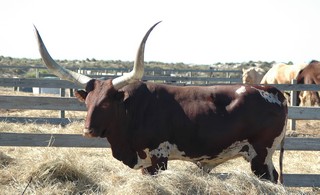 It’s great that we had good friends to help celebrate the New Year as the weather was the pits. It was quite cold and often rainy. One day the four of us drove up the island as far as the road goes. Happened to see this bull in a pen along the road. Now that is one BIG set of horns. Another day we all went to Matamoros, the Mexican town across the border from Brownsville. The taxi ride back to the border from the market was unique. The 30 year old cab had the front right tire half flat, a loud knock in the motor - crankshaft? we’re not sure what – but it got us there and – the cabby was great. He gave us a rundown on all the buildings we were seeing as we travelled the couple of miles back.
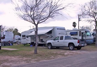 We left the island Jan 4th and headed about 80 miles up the Rio Grande river to Tradewinds RV park in Mission, TX. We had spent a week there last winter and decided that we would spend a month this year. There is a terrific group of people, many from Ontario, and we were looking forward to golfing, happy hours and cards. Well, we had the cards, some happy hours but only two days of golf. We had a few days of good weather when we arrived and then it turned cold and wet. Folks who have been coming to the valley for 20 years said that they had never had it so cold and wet for such an extended period. Last year the campground was basically dust – this year, as you can see, it was grass.
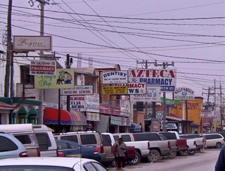
Towards the end of our stay, we once again crossed into Mexico to do some shopping. This time we went to Progreso – I swear it is the Dentist & Pharmacy capital of the border towns. In the picture to the left, there are signs for 4 pharmacies, 3 dentists and one doctor, and that is just one side of one block of a street probably 10 blocks long. Many Winter Texans go across to have dental work done and to get prescriptions. Much cheaper! One of our neighbours in the Park has gone over to the same dentist for 12 years. The pharmacies were all very clean and professional looking and many of the people in the park get their prescriptions filled there.
We visited RV friends at other parks in the valley. One couple, Heather & Tony, here from England, are travelling in their motorhome with their 2 dogs. We have met up with them in Waterloo, ON, Shediac, NB, Milton, ON and now Mercedes, TX. This lifestyle just puts your friendships on a different schedule than most.
Super Bowl was always a party when we had a house, so – we held one in our trailer. We found out we can comfortably hold 12 and everyone could still see the TV. Dinner at half time was crowded but manageable. I provided the chili and with everyone else providing the rest, no one could say they were hungry.
We did many of the same things as last year and then more: the Citrus Parade was on again and our park won 3rd place for our float, we went to Ropa Ustada (used clothing) and dug through piles and piles of clothes, we went out to eat at Pepi’s, we went to old McAllen to shop and we ate the wonderful valley grapefruit and oranges, we played bingo and we played cards, we went to craft shows and RV and Travel shows and found out just how fast a month can go.
There was a big pot luck the night before we left and with about 35 at it, you can imagine the amount of food! One reason we will be glad to be on the road is because we are eating way too much! It seems every time we turn around there is food.
But, both of us are still in travel mode and we want to see many more things. We are heading into Big Bend National Park and will be in touch after we leave there.
Keep smiling
Bernie & Ross
Posted by Bernice at 11:36 AM | Comments (3)