« July 2005 | Main | September 2005 »
August 29, 2005
Alberta
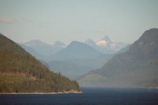
It is only a short trip of about 225 km from Field, BC to Chestermere, AB (east of Calgary) which was our destination for the day, but once again we went through some magnificent views in the Rockies.
We arrived in Banff in time to wander around the town before lunch. It certainly caters to tourists, but has avoided being tacky. We felt that the town has maintained a presence that fits in with the incredible scenery that surrounds it.
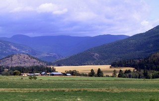
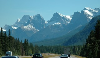 The road toward Calgary runs through the Bow River valley and for about another 40 kilometres we were still overshadowed by the towering peaks. The area around Canmore is particularly beautiful with the Three Sisters dominating the landscape. Every direction you look there are massive mountains.
Words are inadequate to describe the mountains. At once you are amazed at the stunning and awesome beauty, you feel overpowered by the shear size and mass of the rock and you are astounded by the forces that created them. As much as seeing – you feel them.
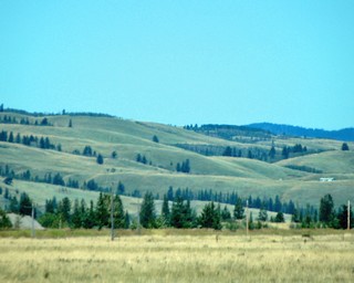 And suddenly you are out of them and into the rolling foothills west of Calgary.
When you look behind you, you can see the mountains looming there, but as you continue east they gradually disappear into the haze and you’re not sure then, if it’s the mountains or a cloud bank.
We spent a couple of nights in the Calgary area where we visited with Bernie’s cousin Carl & his wife Shannon. Thanks cuz, those Alberta steaks were great!
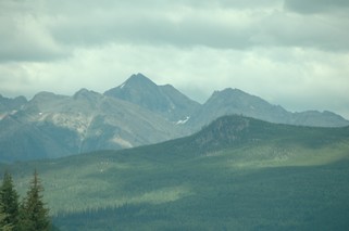
Early Saturday, August 27th, we headed north. We are now in country where the sky seems endless. What a change from the mountains just a short distance to the west! Early on, we think we can still see them, but as the mountains angle to the north west and we are heading straight north they have soon totally disappeared. We will miss them as we have been surrounded by or at least able to see mountains of all types since we approached Yellowstone the first of June. I guess that’s not exactly true as there were no real mountains in southern Idaho or eastern Nevada – but you get the idea.
We stayed to the east of Edmonton and decided to treat ourselves to Sunday brunch in the city with friends. Deborah and George, it was great fun. Hope to see you in November when you come to Toronto.
On Sunday afternoon we headed east. From now on that will be the main direction of our travel as we are headed back to Ontario. Our elder daughter Amanda, who lives in the Bahamas, is expecting our first grandchild in October. She is coming home to have the baby here and will be arriving on Sept 11th. That is our target date to be back close to Cambridge, where she will be staying with our other daughter Michelle.
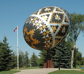
The road east goes past Vegreville, the centre of eastern Alberta’s Ukrainian culture, where you can find the world’s largest Ukrainian Easter Egg or pysanka. It’s 31 ft. high and made of more than 3,500 pieces of bronze, gold and silver aluminium.
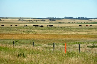
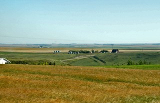
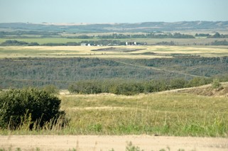
The land is still generally flat and we see many large herds of cattle. This area has more grassland than grain and does seem very prosperous although the ranch buildings are distant from each other.
We arrived in Lloydminster in the late afternoon and went to the visitor centre to get maps and information on Saskatchewan. Lloydminster is a city divided. Well, at least one half is in Alberta and the other half is in Saskatchewan. Common to them both however, is the number of heavy oil refineries. It’s the chief industry in the town.
When we were at the visitor centre, we ask for directions to the campgrounds in the area. This is the first time on our trip that we have encountered no vacancies. Fortunately, there was a WalMart in town so we stayed there in the parking lot. The Husky Truck Stop said that we were welcome to stay in their lot as well. With the solar now working well, we are comfortable anywhere.
Tomorrow, it’s into Saskatchewan.
Bernie & Ross
Posted by Bernice at 11:14 PM | Comments (0)
August 27, 2005
British Columbia
 On Saturday, August 20th, we caught the 11:00 AM ferry from Nanimo on the island, to Horseshoe Bay on the mainland. The mainland coast has mountains rising right out of the water. As we had arrived around noon we decided to head up along Howe Sound to Squamish, which claims to be the premier wind surfing destination in Canada. Of greater interest to us was the West Coast Railway Heritage Park, which has the largest collection of rolling stock in western Canada. Another railway fix for Ross. Guess what – another curvy, narrow, hilly road – but this one is getting a major upgrading because of the Winter Olympics coming to BC. Looks like its going to multi lane all the way to Whistler.
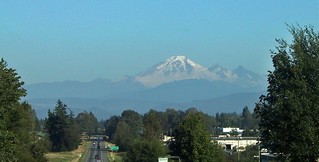 We stayed that night in a WalMart parking lot in Chilliwack. As we went east and then north along the Trans Canada we could easily see Mount Baker across the border in Washington state. It’s another of the volcanic mountains sitting by themselves. This area of southern BC is agricultural and appears to be very prosperous. We followed the Fraser River to Hope and then took the Coquihalla Hwy to Merritt before turning east.
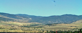
Merritt is set in a wide valley of long rolling hills and fertile lowlands. The road from there to Kelowna was one of the most difficult for the truck that we had travelled. It didn’t have sharp turns or exceedingly steep grades, but it did have long hills – up to 20 km in length – and consistently steep grades of 5 to 8%.
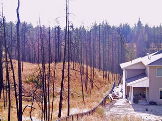 We all remember the terrible fires that burned so many homes in Kelowna. Well, they are rebuilding. We drove out into the area and took this picture of the fire area and a new home built on the foundation of one that had been destroyed. The green is starting to come back and it is interesting to see the pockets of trees that were spared by the fire for no seeming reason. We visited friends, Jackie, Ace, Jenna and Jeff who had moved to Kelowna about 23 years ago. That’s a lot of catching up to do.
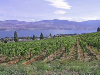
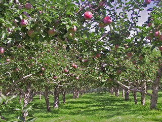
As we were in the Okanagan valley, we took the opportunity to take a tour of a winery as well as an apple orchard. The orchard farm was 140 acres with approximately 1/4 million fruit trees. Quite an operation. The weather was HOT and we found out that it is very normal in the valley. However, as in all of the other mountain valleys that we have been in this summer, it does cool off nicely at night.
On Tuesday, we continued up the Okanagan and stayed in Revelstoke that night. Again we saw fertile valleys set among the hills – big hills, but in most cases not the huge mountains that we are headed into. Just before we reached Revelstoke, we stopped to visit Craigallachie where, in November 1885, the CPR rail line from the west met the line from the east .
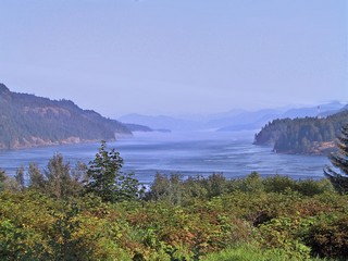
Interestingly, most people think of the Columbia River as being in the U.S. After all, we visited the Columbia Gorge in July and it is a large part of the border between Washington and Oregon. Well, Revelstoke is on the Columbia River which originates from Columbia Lake in BC just west of the Rockies.
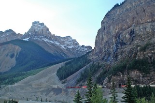 From Revelstoke we continued toward the east and over Rogers Pass, the central route through the Rockies. Through most of the trip from Vancouver we have been running within sight of railway tracks. The railways found the best way through the mountains, usually in a river valley, and the highways, in general, followed along. When we arrived in Field, BC, we could watch the trains on the CPR mainline from our campsite. We also were close to the spiral tunnels and watched two trains go through them. The tunnels are spirals built mostly inside the mountains in order to get enough elevation at a reasonable grade to get over the mountains at Kicking Horse Pass.
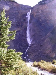 Early the next morning we travelled up the Yoho Valley Road to Takakkaw Falls (“magnificent” in the Cree language). The falls drops 1,265 ft. in all, making it one of the highest falls in Canada. Unfortunately, by being there in the morning the sun’s angle was not on the falls. Our pictures would have been better in the afternoon but we were planning on being into Alberta by then so didn’t stay.
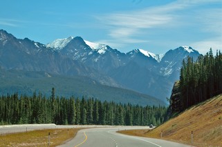
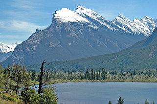
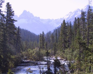
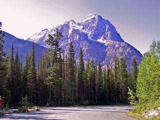
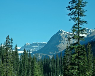
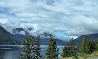
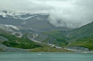
We really are in the mountains now and every turn of the road is another overwhelming view. It is difficult to express in words the power of the mountains. This truly is something that you feel. These mountains are different than the ones we have travelled through these past two months. This is rugged, shear, snow and glacier, evergreens and aspens, rugged bolders and ice cold rivers. It is overpowering.
Below I am showing just a few of the scenes as we travelled.
Our next journal will be from Alberta.
Ross & Bernie
Posted by Ross at 01:28 AM | Comments (11)
August 25, 2005
Vancouver Island - Pacific Rim
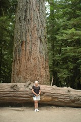
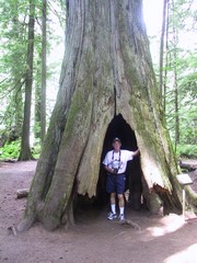
On Vancouver Island the majority of the settlements and population are on the east side and in the south. To reach the Pacific you go directly across the Island including over some significant mountains. We went only as far as Port Alberni on the first leg. From there we visited Cathedral Grove, the location of some of the largest Douglas fir trees on the island, including one estimated at 800 years old. To stand beneath these huge trees gives you an overpowering sense of awe. The tree standing behind Bernie is the biggest in the grove!!
For the last month, one of the tastiest parts of this trip has been the blackberries. They grow wild everywhere in the west. We first encountered them in Oregon but they were still green. However, as we gradually went north they ripened. In Surrey, before the cruise, we had berries picked from bushes right beside our trailer. I think however that Vancouver Island was the hands down winner as the berries were at their very peak when we were there. They look like black raspberries, but are larger and have quite a different flavour. They have to be really ripe or they are bitter and their canes have wicked thorns. The campsite in Port Alberni had huge bushes right outside our door. We had berries and ice cream every night, as well as picking and eating them right off the bushes.
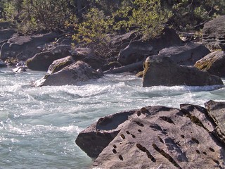
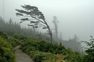
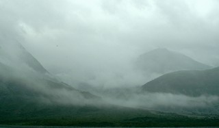
 On Wednesday, Aug 17th, we headed over the mountains to Ucluelet (u-clue-let), on the Pacific. It had rained heavily during the night and we travelled with clouds hugging the mountains for a good part of the morning. Once again we travelled on another very twisting, narrow road – this time with the trailer. A lot of travel in the mountains follows river valleys, so although there are some grades, in general it is reasonably flat. To get to the Pacific Ocean on the island, you have to actually go across the mountains. The road, in a number of places, is cut right out of the side of the hill and is very narrow. On a couple of the bends, we were glad that we didn’t meet anyone, as the rock hung out over the road and we were across the yellow line.
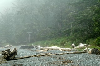
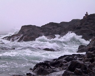 After getting set up at the campground in Ucluelet, we headed to the Wild Pacific Trail which skirts the rugged west coast where the rain forest meets the headlands and beaches.
The headland here is very rugged and the waves are substantial, however August is one of the calmer months. Apparently, this trail is one of the best for watching the winter storms. We walked a 2.5 km trail which was among the most beautiful and dramatic we have seen on the whole trip.
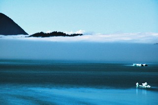
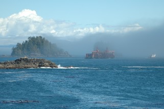 We had arrived at the trailhead at about 2:00 PM and could hear the fog horn as we arrived, even though as we walked through the woods to the ocean the sun was shining. When we arrived at the first overlook, we found out why. Off shore was a fog bank that was slowly moving toward shore. As can be seen in the picture to the left, we watched a tug pulling a barge disappear. The fog had finally closed in totally by about 4:00 PM. When we talked to the staff at the Information Centre they said, “ Didn’t anyone tell you we call this Fogust, not August, on the coast?”
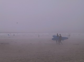
The next day we visited Tofino on the north side of Pacific Rim National Park. It’s an interesting town, but no more so than any number on quaint and unique towns we have seen on our travels. It is the jump off point to visit the Clayoquot area. We did however visit Long Beach (yes, another one – I think this is our third this trip). It is a wonderful stretch of white sand that is considered the surfing centre of Canada. But – wear your wet suit –the water’s cold. They even surf as the fog rolls in.
Friday, we headed back to the east coast of the island to Qualicum Bay, so that we could catch the ferry Saturday morning from Nanimo back to the mainland.
We’ll write to you from over there.
Bernie & Ross
Posted by Ross at 11:54 AM | Comments (2)
August 23, 2005
Vancouver Island - Part I
In our travels, one of the best parts of it has been the people we have met. We told you about Tim and Jan in Jerome, Idaho but there was also Royce & Sue in Reno, Dick & Brenda in Chico, Sheila & Ray and Jay & Marcia in Rogue River, John & Betty in Collier State Park, Vic & Zenda & George & Arlene at the rally in Redmond. We have received information on things to do and see, suggestions on roads to take, advice on where to shop and always friendship, laughs and great conversation. Thanks everyone.
We caught the ferry from Tsawwassen to Swartz Bay on Vancouver Island late Sunday morning. George and Arlene (see above) had suggested that as they live quite close to the ferry docks, when we got to the island we could park the 5th wheel at their place as we explored the Saanich Peninsula and Victoria. We did – it was great – thanks guys. However, as we followed the directions to get there, we headed down a “dead end” road. Let me tell you, when you are pulling a 32’ trailer, the words “dead end” strike terror in your heart because you have no idea if you will find a place to turn around. Their farm was at the end of the road so of course we were fine. That first evening the four of us strolled Sidney harbour and then went for dinner to Dunsmuir Lodge overlooking the valley. George & Arlene’s farm is the open area at the back right of the picture.
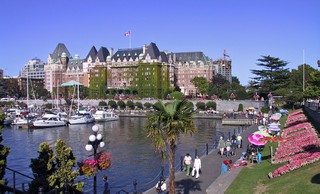
The whole southern part of Vancouver Island seems to be flowers. They are wonderful, with hanging baskets, parks full of flower beds and every house has a profusion of flowers. Victoria in no exception – a beautiful city. We took a city tour and also took a tour of the Esquimalt Naval Base. This was very interesting as our nephew Steven had been stationed there for a time.
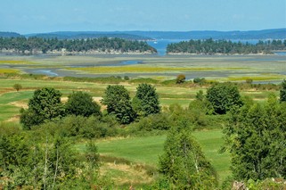
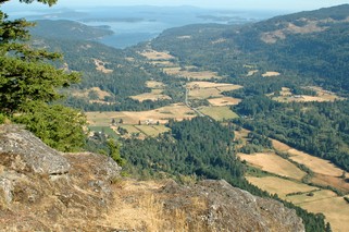 We have heard about Salt Spring Island all our life, and how beautiful it is, so on Tuesday we took the ferry there and spent the day. There was a sign on one of the roads about a cheese factory so we headed down a dirt road to find it. It was goat and sheep cheese made from the milk from their own animals and was fabulous – expensive, but fabulous. They also sold crackers or maybe you would call it a type of melba toast that was also made locally and went perfectly with the cheese. On the way back to the ferry, we drove up to the Mt. Maxwell lookout, 11 km on another narrow, rough, dirt road with a great view at the top. We saw farming in the valley that we didn’t realize was there as you could not see it just driving past on the roads. It is a very pretty island, but we were disappointed that we couldn’t see more of the coast line.
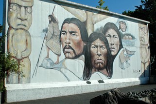
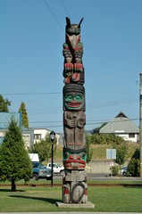
The following day we headed north up the Malahat highway to Chemainus. This little town, in a bid to survive after the lumber mill closed, started with murals by local artists and now has attracted artists from around the world. There are more than 30 on walls of buildings though out the town. Just south of Chemainus is Duncan where there are more than 80 totem poles dotting the town. Travelling between the two towns along the east coast of the island there are great vistas looking toward the Gulf Islands.
 We continued up the island to spend a couple of days in the north, with an overnight stop in Campbell River on the way. It was Friday night and about 11:30 we went for a walk along the shore looking out to the Inside Passage. Sailing south was the Zaandam – one week after we had been on her, on the same schedule. She looked beautiful with all the lights. Just north of Campbell River is Seymour Narrows, where the cruise ships cautiously sail as the passage is so narrow.
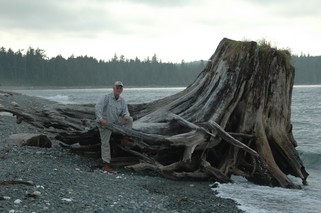
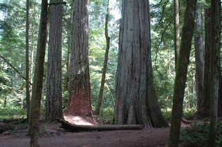
Our base to explored the northern part of the island was a campground just north of Port McNeill . It was right on the water and you can see how huge the original trees were as Ross is dwarfed by the stump of one. We also were fortunate to be able to watch two bald eagles one evening while we were out walking on the beach.
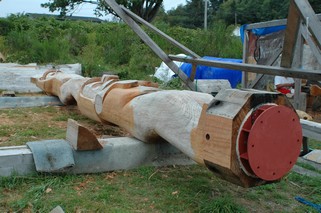 One day we took the ferry across to Alert Bay, the traditional home of the ‘Namgis First Nation and the center of Kwakwaka’wakw culture. We visited the U’mista Cultural Centre which houses the repatriated elaborately carved masked used in the Potlatch ceremony. They had been confiscated when missionaries and the government attempted to “civilize” the native people. We also saw a totem pole, scheduled for export to Europe, in the process of being carved. We hiked up the hill to see the world’s tallest totem pole – I think they said it was about 200’ high – and sitting on the very top of it was a bald eagle. Very impressive. We visited Telegraph Cove on our return to the big island and the following day headed south.
We’re going to send a separate journal on our visit out to the Pacific Rim as it was quite spectacular.
Bernie & Ross
Posted by Ross at 01:42 PM | Comments (1)
August 12, 2005
Alaska - Part II
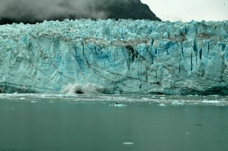
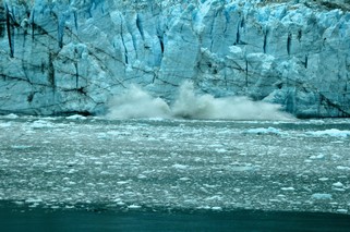
As we were arriving in Glacier Bay National Park, we travelled through quite thick fog which obscured the land that we were passing. As we arrived at Margerie Glacier there was some clearing although the overcast remained. The Park Wardens told us that because of the overcast, the blue of the glacier would show much more. In the sun it is whiter. We were very fortunate as the glacier calved (chunks broke away) 6 times during the 1 1/2 hours we were close to her. In the picture above and the one below, the white breaking the surface of the water is the splash from one of the chunks that broke off. This wall of ice is about 250 feet high above the water and about the same under the water.
 The glaciers in the mountains feed hundreds of streams and rivers that wind their way down the sides and into the bay. We spent the whole day in Glacier Bay and saw 5 or 6 glaciers.
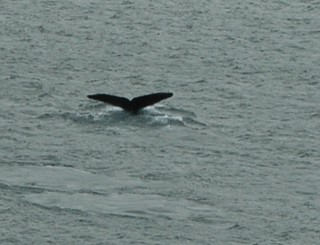
On the way out of Glacier Bay we were treated to a visit of a pod of whales. We watched them blow, surface and dive for probably 20 minutes. One of them surfaced about 50 feet from the ship. The Captain immediately threw on the bow thrusters to move away from it. When whales are spotted the ships are to stay a specified distance from them. Of course the captain has no control over where the whales swim so sometimes they do get very close. This is where we now start to head south toward Vancouver.
The next day, Thursday, we arrived in Ketchican shortly after lunch. Ross says that he will never complain again about how hard it is to park the RV after he watched the docking of this ship.
 We walked around town a bit, stopping and talking to a few fishermen on the short bridge. The salmon were running and there were probably 25 to 30 people fishing off the bridge. We watched the salmon trying to navigate the rapids. A little further up the river, there is a fish ladder to help them past the falls. Apparently, the addition of these fish ladders on various streams and rivers has greatly increased the success rate and thus the overall salmon population.
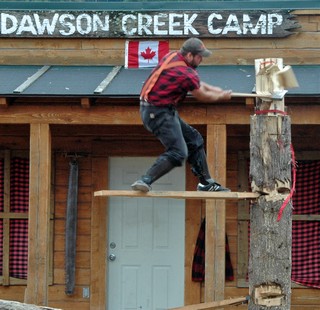
In the afternoon we went to the “Great Lumberjack Show” which was a lot of fun. There were some great displays of skill – wood chopping, log rolling, tree climbing. The picture on the left shows one of the lumberjacks chopping down a stump (tree) while standing on a plank about 6 or 8 feet above the ground. The real loggers did this to get above the large root area and stump at ground level.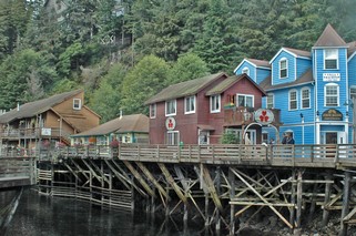
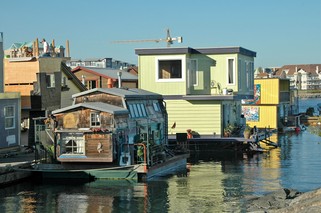
After the show, we walked up Creek Street, which was the red light district of Ketchican and is all built on pylons over the creek. The houses are original and most have moss growing on them. The part of Alaska that we have visited is considered temperate rain forest and Ketchican can get 100 inches of rain a year but very little snow. We were told that if it wasn’t raining when we got off the ship it would be by the time we returned. They were right.
Friday was a sailing day as we headed back down through Queen Charlotte Sound and the Strait of Georgia. There were wonderful vistas of the B.C. mainland mountains to the east and wooded mountains of the north of Vancouver Island. We started seeing civilization before it got dark and as we sat at dinner that night there were lights on a continuing basis. When we awakened on Saturday morning we were just arriving in Vancouver to dock. We had a 10 AM disembarkation time as we did not have flights to catch etc. Anyone with a tight connection schedule got off first. As the cruise had been in the US there were even arrangements for US citizens to go “in bond” to the airport so that they did not have to go through first Canada & then US customs.
We said our goodbyes to Barn and Shell and the rest of the gang, took a cab to the dealership to pick up our truck and head back to the campground to see how the trailer had fared in our absence – and to do laundry.
Sunday, Aug 7th we are heading to Vancouver Island
Bernie & Ross
Posted by Ross at 09:31 PM | Comments (1)
August 10, 2005
Alaska - Part I
We crossed into Canada of Wed. July 27th and it was very easy. Took about 2 minutes as there was no line up at all and customs basically waved us through. Our campground was only about 5 km from the border and from there over the next couple of days we toured the White Rock, Langley, Surrey area. We had arranged with the campground to park the trailer in a field while we were on the Alaska cruise. We had planned on going in to Vancouver and staying in a hotel close to the dock on Friday – but – when we found out that the hotels in that area were $250 to $300 per night we went to plan B. We stayed at the campground one more night.
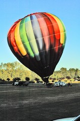
That Friday evening, we were entertained when a hot air balloon crew arrived and set up in the field about 100 yards from us. They do charter rides and had 11 people they were taking up. It was most intriging to watch the whole process. They can’t control where they go so they have a chase car that follows as best it can to pick up the passengers when it lands. If we had gone downtown to a hotel we would have missed this.
As we were almost due to have an oil change, tire rotation and differential service, we contacted a GM dealer in the city and made arrangements to have it done while we were away. They did the work and then kept the truck for us for the week and even paid for the cab ride to the ship. Had we left the truck at the campground the cab would have been about $90.
We met Barnaby & Michelle, who had our tickets, and then boarded the ship – Holland America’s Zaandam – about noon on Saturday. Barnaby’s parents were also on the cruise, as well as his grandmother, an aunt & uncle from England and great aunt and cousins from Vancouver Island. There were 12 in our group. It was great to have others on the cruise to meet for meals, etc. but we all did our own thing during the day and while on shore.
On boarding, we of course headed directly to the lunch buffet as our luggage and rooms would not be ready until later that afternoon. One thing we learned quickly is that you never go hungry. The food was excellent with lots of choices and at least one restaurant was open at all times. Our dinner seating in the more formal dining room was at 7:45 and we had a window table. The service was wonderful and nothing seemed too much trouble for any staff member. That was true all over the ship, everyone went out of their way to provide you with every service, right down to carrying your tray from the buffet line to a table.
We left the dock in Vancouver at 5 PM and sailed up the Strait of Georgia between Vancouver Island and the mainland. Sunday we continued up the Inside Passage with signs of civilization becoming less and less. At one point we had a whole school of dolphins playing around the ship. The sea was quite calm although on Sunday morning as we were in Queen Charlotte Sound away from land there was quite a roll. No sooner had we noticed the rolling, than we could feel the stabilizers employed and the ship settled right down again.
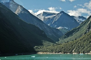
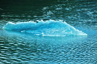
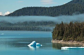
We were awakened on Monday morning by the speaker in our room announcing that we had arrived in Tracy Arm. This is a beautiful fjord just south of Juneau. We saw our first iceburgs – not the huge ones that you see in pictures, but small ones floating everywhere. They were the most beautiful blue and when the sun shone through them were almost irridescent. The water is also blue green which is a result of the glacial silt that is carried by the streams from the glaciers. As we left Tracy Arm we went through a fog bank so thick that you couldn’t see.
In the afternoon we docked in Juneau, the state capital of Alaska. There are no roads from the outside into Juneau so it can only be reached by sea or air. There were a number of tours that could be taken from there and Barn & Shell went out to the Mendenhall Glacier. We stayed in town and took a tour of the State Capital building as well as wandering around the shopping area. We don’t buy much as we have no place to keep it, but we enjoy looking. The ship left Juneau at 11:00 pm but we had come back about 8:00 pm for dinner.
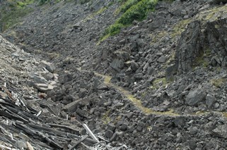 Tuesday when we woke we were dockside in Skagway. At noon we took the train, the White Pass & Yukon Route Railroad for a half day narrated ride. The rail line was built in 1898 to carry supplies and people (who could afford it) to the Klondike gold rush. The picture at the left is part of the trail that the miners used and is so narrow that you couldn’t meet except at certain points. Each miner had to have with him enough supplies to last for a year (about 2000 lbs) before the Mounties would let him cross into the Yukon. It took them numerous trips up this trail and many pack animals and people didn’t make it.
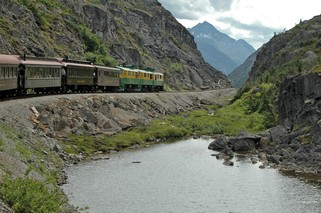
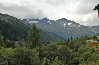
The train tracks are narrow gauge, which means the rails are 3 feet apart. A regular track is 4 ft 8 1/2 inches. By using the narrow gauge, the track bed only needed to be 10 feet wide instead of 15 feet. That was very important when they were building on the side of a mountain. The White Pass summit is 2,865 ft and is about 20 miles from Skagway which is at sea level. The scenery is beautiful with great mountain vistas. We saw mountain sheep in the distance and a bear beside the tracks. All in all a wonderful 4 hours.
Tonight we will set sail for Glacier Bay and will be there when we wake in the morning. We’ll tell you about it in the next journal report.
Ross & Bernie
Posted by Ross at 05:55 PM | Comments (0)