« October 2008 | Main | December 2008 »
November 11, 2008
Bryce Canyon and the Grand Staircase-Escalente
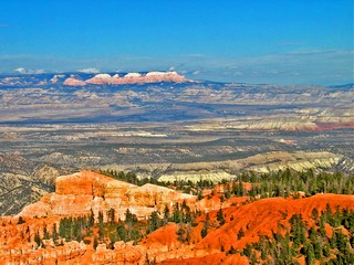
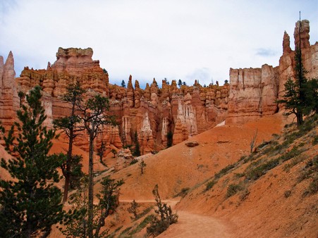
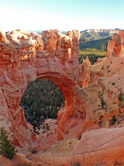
The featured vista from the rim is called the Amphitheater, a bowl containing thousands of pinnacles of multi-coloured rock, each a different size and shape. Our first day we did the walk from Sunrise Point to Sunset Point and up to a towering lookout over the Amphitheater. It is surprising how long it takes to walk only a couple of miles, because of the number of times you stop to photograph the changing vistas and say “Ah -Wow-Look at that-spectacular” etc, etc. From this rim you can see about 90 to 125 miles, including the Aquarius Plateau, at an elevation over 10,000 feet, the highest plateau in the U.S.
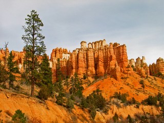 Bryce (named after a Mormon cattle rancher who settled in the area around 1875), is very special because it is the only national park with its type of hoodoo rock formations in the United States. Bryce, established in 1928, is one of the smallest (only 36,000 acres) parks we visited but it is absolutely a one-of-a-kind experience.
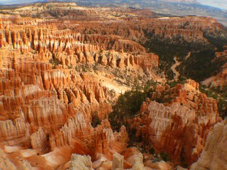
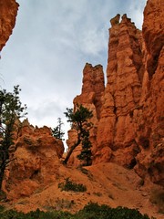
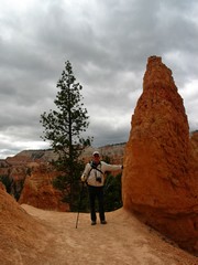
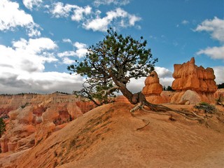
Our second day we decided to hike down into the canyon and selected the Queen’s Garden Trail because it has the fewest sharp edges and drop-offs which as you have heard, are my (Ross’s) least favourite type of landscape. As I’m sure you’ve already guessed, going down was much easier than coming back up but well worth the effort. Even with the attached pictures it is hard to describe the beauty of the pink, orange, chocolate and white layered spires at Bryce.
 On day 3 we completed the drive to Rainbow Point and return – called the Rim Road as it curls along the very rim of the canyon. There are numerous pull-outs to view the seemingly endless array of outstanding rock formations. Although only 17 miles, it took more than 4 hours to get back to the Visitor Centre.
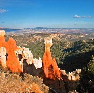
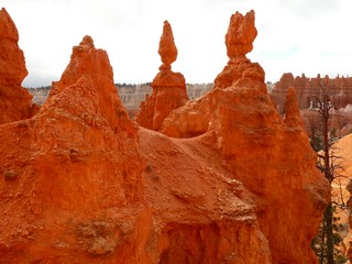
When we were at Bryce a number of years ago, Bernie had done a painting of “The Hunter” – the hoodoo pictured here. Unfortunately, progress, in the guise of a better parking area has taken the artistic viewpoint away. Bill and Barb, enjoy the painting. It is now definitely a one of a kind.
Bryce Canyon draws about one and a half million visitors a year and the fall is an ideal time to be there – cooler temperatures and less crowded. During our first visit (in summer) we arrived for sunrise (just under 40F degrees), hiked into the canyon and returned for lunch (just over 100F degrees). In these dessert landscapes, you can freeze and boil in half a day.
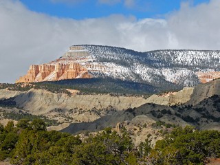 Our last day in this area we drove to Boulder (Utah not Colorado) through Grand Staircase/Escalante, some of the most remote, un-populated and very rugged miles we have travelled. The Grand Staircase is a series of giant geological steps from the south rim of the Grand Canyon to the Aquarius Plateau, already mentioned. Each ‘step’ or layer is a different colour.
It had snowed in the higher plateaus the night before, so there was a different perspective.
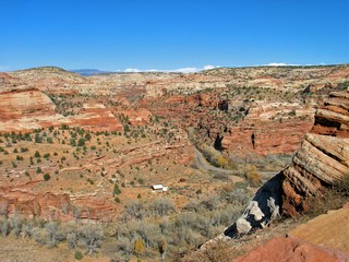
Depending on the elevation of the road, we were in either, grey, red or black rock.
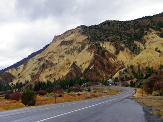
In the picture to the left, we were up high. Notice the road on the right hand side and the white in the middle is actually a working ranch.
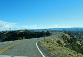
Sometimes we travelled the absolute razor back of the ridges.
After a very enjoyable lunch in Boulder, we drive back to the KOA at Cannonville for domestic duties like laundry.
This, our second visit to Bryce Canyon, we both agreed had been as good as our memory of the first visit. It’s satisfying to revisit and again be impressed.
In travel mode again tomorrow, November 6th.
We've heard from Jim & Carolyn and it looks like we'll meet them again at the campground in Zion.
Posted by Bernice at 05:05 PM | Comments (5)
November 06, 2008
Capitol Reef National Park
Early on Halloween we left Tony and Heather and drove to Capitol Reef National Park for a day’s exploring.
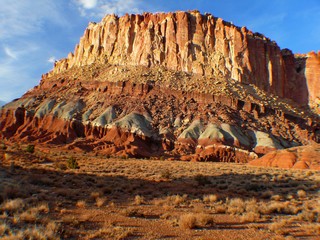 It is a little different than most parks, being long (almost 100 miles) and narrow, and at 242,000+ acres is the second largest of the five parks we visited in Utah on this trip. A national park only since 1971, Capitol Reef resembles a giant wave (of rock, not water) called the Waterpocket Fold, which rose up from the dessert floor about 65 million years ago. The Navajo call the area the ”Land of the Sleeping Rainbow” because of the variety of colours in the rock layers that form the reef.
We stopped briefly as we entered the park from the west, on State Rout 24, to view the first of the unique rock formations but then decided to go the Visitor Centre to ask their advice on a good day’s worth of sightseeing.
As we drove over a hill about a mile west of the Visitor Centre we came upon a most unexpected view! 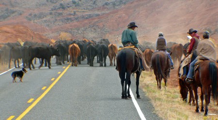
The back side of about 100 head of cattle being herded east through the park. The cattle drive to their winter range happens on the last Saturday of October every year and because of the high and rugged rock formations, the highway is the only way through. Cattle are not exactly Olympic athletes so it took quite a few minutes to work our truck through the herd. Most of the driving was being done by one small Border Collie dog, while the half dozen cowboys just seemed to be along for the ride.
While at Arches, we had met Carolyn and Jim, from Connecticut, and had spent time together seeing the sights around Moab. As we walked toward the Visitor Centre, there they were, walking toward us from the opposite end of the parking lot. Small world – amazing timing.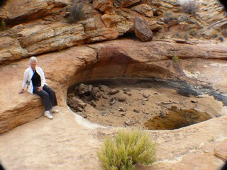 The park rangers strongly recommended that we take the 25 mile Scenic Drive, formerly called the Blue Dugway, and suggested we do the 1 mile hike into Capitol Gorge at the end of the road, including a fairly strenuous climb to two pools (eroded into the sandstone), called the Tanks, high above the valley.
These depressions in the rock hold water after the rains, a vital element for wildlife in the park.
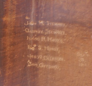 One of the highlights of the hike is a flat vertical rock face in which are carved many names and dates of the people who used the route , the bottom of the gorge, over a hundred years ago when it was the only way in or out or the area. It actually was a wagon trail until the new highway was built, and since then is only open to foot traffic. There must have been dozens of names and dates and is now called the “Pioneer Register”. The first date is 1871. If people now scratch their names on the rocks in a National Park it is called vandalism.
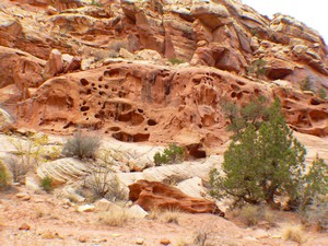
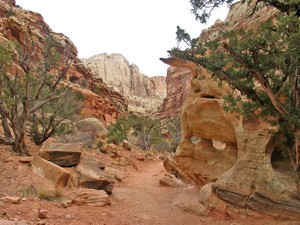 We also hiked the Grand Wash, which passes the Olyer Uranium Mine (closed for many years). The Wash drains into the Fremont River and although dry most of the time, the water sculpted rocks and walls of the wash show evidence of much more violent times.
As we followed the scenic route back to Hwy 24, we travelled along the Western side of the Waterpocket Fold. With the sun shining on the cliffs, it was an awesome spectacle.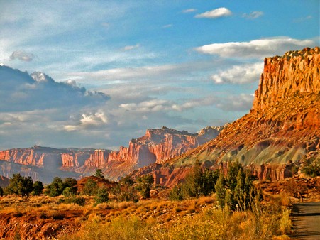
Before we left the park, we drove through the old village Fruita, an early Mormon settlement of which only the original schoolhouse and blacksmith shop remain. The Fremont River cuts through the Fold and there are pioneer orchards and fields beside it. The highway, only completed in 1962, follows the river.
We left the park near dark for the 60 mile drive back to Richfield having seen yet another example of nature’s endless geological diversity. By then Tony and Heather had arrived at an RV park about 10 miles west and we stopped to say goodbye. Tony presented us with some Halloween candy bars and Heather had fresh scones and coffee.
 November 2nd saw us on the road again for a 4 day visit to Bryce Canyon National Park, our longtime favourite from our first trip to Utah years ago. Part way down US 89 as we rounded a curve, we arrived at Big Rock Candy Mountain, a unique tourist stop that is the basis of the folk song of the same name. On a rainy Sunday morning in November it wasn’t very busy and the colours in the rock that supposedly gave it it’s name didn’t really show. After all the vibrant rock we have seen it didn’t live up to expectations.
We went on to the KOA, south-east of Bryce in Cannonville, where we set up camp for the next few days.
Bernie & Ross
Posted by Bernice at 06:55 PM | Comments (4)