« Northern Alberta & Northwest Territories | Main | Dempster Highway »
June 17, 2008
Yellowknife, NWT to Dempster Corners, YK
A couple of note-worthy sightings as we headed back on our long detour:
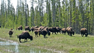
The Highway from Yellowknife borders the Mackenzie Buffalo Preserve and on our return trip we saw close to 200 animals – one herd we counted 67 adults and 7 calves. We waited about 15 minutes for the herd to cross the road. 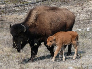
The babies were so cute and stayed right beside the Moms.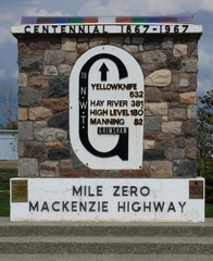
We have now travelled the full length of the Mackenzie Highway which begins in Grimshaw, Alberta and ends in Yellowknife, Northwest Territories.
We headed west from Grimshaw and arrived in Dawson Creek, British Columbia mid day on May 30th, 2008.
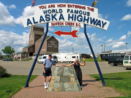
A sign at the obelisk reads:
At this spot in the spring of 1942 at the height of World War 2 the US Army engineers began the construction of the overland route to Alaska. Nine months later at a cost of over $140,000,000 the road was completed. This is a road construction feat unsurpassed in modern times. 11,000 troops & 16,000 civilians were employed in this project.
There are 133 bridges & 8,000 culverts embodied in the 1523 miles of gravel highway. The rattle and roar of the mighty bulldozers was a source of amazement to both the local white man and the northern Indian.
Over this lifeline to the Northwest, thousands of troops, food & war supplies have been transported, in more recent times the mighty H bomb was known to travel this route. It was maintained by the Canadian Army until April 1964; maintenance was then taken over by the Dept. of Public Works, Ottawa.
Having now travelled many miles of this road, we are absolutely astounded that it was built in the time frame that they did it.
 The current highway bears no resemblance to the original road. It is now pavement the whole way with gas and other services at regular intervals. The original was a mud track to move military supplies. The road then immediately began continuous upgrades. It has been straightened and flattened, bridges have been built to replace ferries and the road base has been totally overhauled. It’s a long road but no longer the endurance trip it once was.
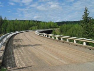
We took a side trip to travel about 4 miles of the original road. This curved bridge with its plank surface is unique.
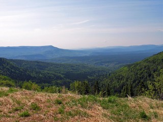
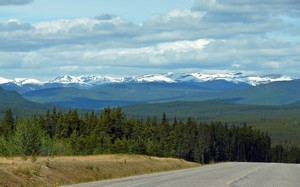
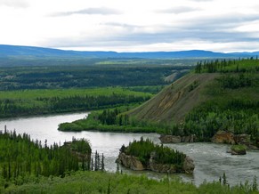
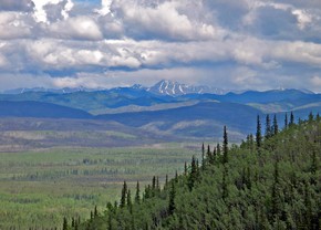
Our second day as we travelled from Fort Nelson toward Muncho Lake, the vistas were beautiful.
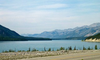
We stayed at Northern Rockies Lodge & RV Park on Muncho Lake. It was expensive – $35.50 for water and 15 amp power – and the sites were marginal. However, they are in the middle of nowhere, they make all their own power by generator and they have a captive clientele. So what did we expect?
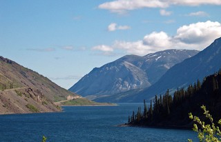
The lake was a beautiful blue green.
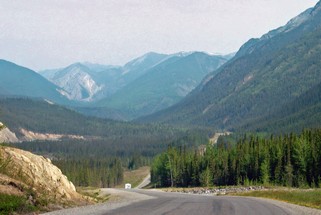
After stopping the next morning for a swim at Liard Hot Springs Provincial Park (I hoped it was the fountain of youth – but no such luck) we continued toward Watson Lake through some very rugged terrain.
There have been some steep hills and some long ones but seldom both steep and long. We travel mainly the river valleys.
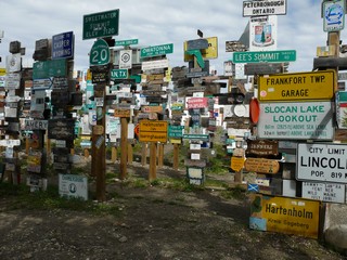 Watson Lake, in the Yukon, was first settled by a trapper in 1898 but now is most famous for its signpost forest that sits right beside the highway and the Visitor’s Centre. It was started by a homesick soldier in 1942 during construction of the Alaska Hwy.
In talking to the staff at the Visitor’s Centre, we found out that there are now over 65,000 signs posted there.
Our travelling partners, Bev & Ron, had brought a sign with them so there was one more by the time we left.
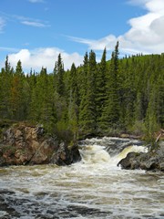
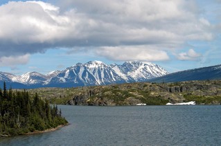
Waterfalls & mountains between Watson Lake & Teslin
Bev & Ron had never been to Skagway and travelling by highway to it is totally different than as we saw it on the cruise in 2005. We decided to stay a couple of nights in Carcross, YK and drive the 100 km down there with just the truck. One of the problems with pulling the trailer on mountain roads, is that the driver doesn’t have much of an opportunity to check out the scenery. Sometimes, it’s nice just to take the truck.
This is a bit of what we saw on our trip to Skagway.
We arrived in Whitehorse, YK on Sat. June the 8th and spent 3 nights there. It’s a thriving community of about 24,000 people. The population of the whole of the Yukon Territory is only around 30,000. It began during the Kondike gold rush and was the terminus of the White Pass and Yukon Route railway. Sternwheelers travelled from Whitehorse on to Dawson City. It was also a major construction location during the building of the Alcan (Alaska) Highway.
Whitehorse is named after the historic rapids on the Yukon river which resembled the flowing manes of charging white horses.
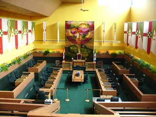 As of 1953 it became the capital of the Yukon Territory and as is our practice, we visited the Legislature.
The regular tour guide was off sick and our “substitute” tour guide turned out to be the Clerk of the Legislature so we had a very informative and insightful visit.
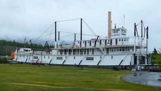
We took a tour of the S.S. Klondike, a restored stern-wheeler that plyed the Yukon River. It was one of the largest ships to travel the route and ran from 1937 to 55.
At the Beringia Interpretive Centre we learned about the ancient sub-continent of Beringia, an area of the Yukon, Alaska and Siberia never covered by glaciers during the last ice age. The water trapped in the ice that covered the rest of North America, caused the ocean levels to drop, exposing the ocean floor between Alaska and Russia. It is believed that this is the route travelled by the first people to enter America from Asia. This ancient area was populated by wooly mammoths, scimitar cats and giant beavers among others.
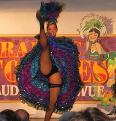 We had a fun night out at the “Frantic Follies”, a Gay ‘90s vaudeville revue.
They also included an excellent performance of the Robert Service poem “The Cremation of Sam McGee”.
We left Whitehorse on June 10th and about 12 km outside the city, we turned north on the Klondike Highway. We’ll come back to this corner on the Alaska Highway on our way out of the north. We travelled quite steadily, stopping for the night at Pelly Crossing and arriving in Dempster Corners, 490 km from Whitehorse and 40 km from Dawson City, the following day.
We stayed at the campground at Dempster Corners, left our trailer in their back lot for 5 days and took only the truck up the Dempster Highway to Inuvik.
That’s the next journal.
Bernie & Ross
Posted by Bernice at June 17, 2008 07:33 PM
Comments
Amazing as usual, folks.
You guys should really consider putting together a book or some other sort of presentation of your experiences. Who knows? You could end up doing lectures on cruise ships. I'd go!
Best regards, and keep the stories and pictures comin',
J & A
Posted by: Jill & Alan at July 14, 2008 08:30 AM
What beautiful views!You must have enough already, Bernie , to keep you painting for years to come.
We love to read about your experiences and shall look forward to the next episode.
Helen.
Posted by: Heln & Ray at July 15, 2008 08:09 AM
Hi there! hope your journey is going well!
Grandma says hello and wishes you all the best!
Posted by: Sydney Larsen at July 19, 2008 03:13 PM
Hi;
Peggy let me know that you had gotten in touch with her - did you happen to see Sandy? I think we were in the same camp ground at Muncho Lake when I was up there on the survey crew. Bernice, you might remember the Riverdale Art Walk where a guy spent forever looking at a couple of my prints - one of them was a sunset on Muncho Lake from about the same location as your shot - small world!
Eric
Posted by: Eric Fergusn at July 21, 2008 12:53 PM