« Southern Prairies - Summer 2008 | Main | Yellowknife, NWT to Dempster Corners, YK »
May 31, 2008
Northern Alberta & Northwest Territories
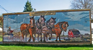 Head straight north of Edmonton on Hwy 2 for less than an hour and you can take a little side trip to the town of Legal (a Francophone community pronounced “Lee-GAL”). The town is filled with numerous excellent murals and we spent close to an hour walking around looking at them.
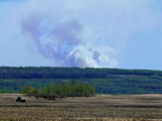
As we continued north toward Athabasca, we could see a massive cloud of smoke to the east. That night on the news and for the next few days we heard about a massive forest fire that had one town evacuated and two homes destroyed.
The whole land was dry and a total fire ban in effect.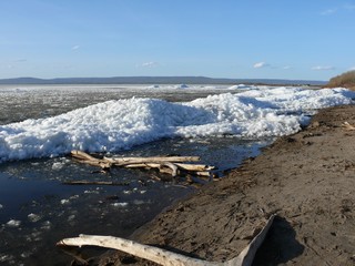
When we arrived in the town of Slave Lake, which is on the south shore of Lesser Slave Lake, we were surprised to see that the lake was still filled with ice – not frozen solid – but ice that moved, and gurgled and shifted and slowly eased east into the Lesser Slave River. The wind had piled it up along the eastern shore of the lake, while the west end of the lake was open.
Leaving Slave Lake 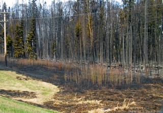 the next morning, May 17th, we travelled Hwy #2 past an area that was still smoldering and fire crews were still in attendance. This part of the road had been closed 2 days before and the campground had been given notice they might have to evacuate. Fortunately the fire was brought under control before that happened. Look closely and you can see the burn on the base of the telephone pole.
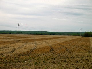 Continuing west and north we passed through High Prairie, stopped overnight in Peace River and then followed Hwy 35 to High Level, AB. This is a vibrant town on the northern edge of the prairies. We learned there are about 600,000 acres of land under cultivation in the area and another 20,000 acres of range land. Both of us were very surprised, as we had no idea that there was so much agriculture so far north. We are almost 800 km (500 miles) north of Edmonton by road.
We camped at a great, little known campground at Fox Haven Golf Course just north of town and stayed 2 nights, planning on playing golf – but it rained. Instead, we took a side trip to Fort Vermilion. It was the Monday of the May holiday weekend so everything was closed and what we saw didn’t inspire us. We didn’t think it was worth the 150 km round trip.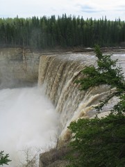
Very shortly after leaving High Level the cultivated land disappeared and was replaced with miles and miles of spruce, aspen and beaver lodges.
We crossed the 60th parallel into the Northwest Territories and continued to Hay River on the south shore of Great Slave Lake. Before reaching there, two scenic waterfalls are right beside the highway. Alexandra and Louise drop 108 ft. and 50 ft. respectively. They are on the Hay river which is almost brown – it’s not really dirty, the water just has a brown tone to it.
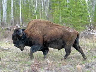 It’s around 276 km south and east to Fort Smith and about 140 km of that is gravel road (as it crosses Wood Buffalo National Park). The truck and trailer got dirty! We stayed at the Territorial Campground in Fort Smith and then travelled in to the Park with only the truck. The Park is the largest in North America, covering about 44,807 sq km (17,300 sq mi). It was created in 1922 to protect one of the worlds largest free-roaming heard of wood bison. It is now home to about 4,300 bison and is also the northern nesting grounds of the endangered whooping crane.
 We spent one day sightseeing and hiking in the Park and were quite disappointed that we saw very little wildlife. The Whooping Cranes nesting grounds are inaccessible shallow lakes and marshes and the bison have such a huge area, that they seldom come to the single summer road that runs part way in. We only saw about 25 bison in total and 2 pair of swans.
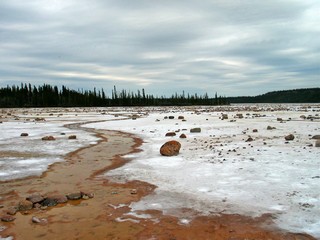
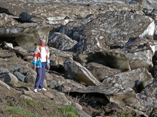
One unusual feature is the Salt Plains, with bolders strewn all over. We reached it after about a 2 km hike through the woods. The white colour is salt, not snow and it looked like something out of science fiction.
We spent one day sightseeing and hiking in the Park and were quite disappointed that we saw very little wildlife. The Whooping Cranes nesting grounds are inaccessible shallow lakes and marshes and the bison have such a huge area, that they seldom come to the single summer road that runs part way in. We only saw about 25 bison in total and 2 pair of swans.
One unusual feature is the Salt Plains, with bolders strewn all over. We reached it after about a 2 km hike through the woods. The white colour is salt, not snow and it looked like something out of science fiction.The weather was generally good. It reached 10C to 12C during the day, got down close to freezing at night and we had mainly sunny days. The locals told us that is quite cool but one of the advantages is that we had very few mosquitos.
 Yellowknife, the capital was next on the agenda. It’s 750 km so we took two days to travel that distance.
The Mackenzie River is crossed at Fort Providence, by a free ferry, although there is construction under way to build a bridge. The river was still full of ice flows and the ferry just churned through them. We camped right beside the river and were amazed at the size of the chunks of ice that had piled on the shore line. Of course by this time of the year they are quite dirty.
The roads have been okay although as in every northern community in the spring there are some problems. Road heaves are much more a problem than pot-holes. Unfortunately, they are hard to see until you are right on them and they give you quite a ride.
The land has been basically flat and tree covered, with a mixture of spruce and aspen, since just north of High Level, AB. Actually, the drive itself is quite easy but boring, as there is nothing to see. When we were about 100 km from Yellowknife, as we turned south east, having gone around the North Arm of Great Slave Lake, we quite suddenly were into granite. This is the Precambrian shield, the same land formation that dips down into Ontario, in the Muskoka district, some 3,500 km away.
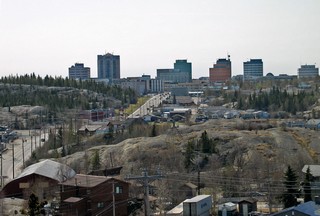 Yellowknife is a modern city of approx. 20,00 which comprises close to half the population of the NWT. Although the Dene hunted in the region for thousands of years, it was permanently settled when gold was discovered in 1934. It is built around lakes and on and around rock outcroppings. All the services you could want are here.
Diamonds were discovered in the NWT in1991 and that’s what is driving it’s current growth. The three mines headquartered here produce about 15% of the world’s diamonds by value. We visited the Diamond Visitors’ Centre to learn about this new industry.
Again we stayed at a Territorial Park. We have not seen any private campgrounds, but the Territorial ones are really quite good and we have had no problem getting in to them. Most of them offer 15 amp electrical hook-ups only, but that is fine as we carry water on board and each one has a tap where we can replenish our supply. They all also have a dump station that we use as required.
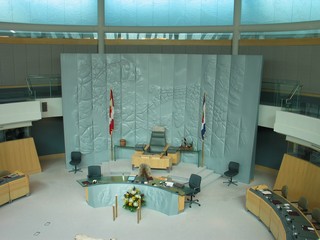 Our visit to the Legislature building, which opened in Nov. 1993, brought out an interesting fact about this Territorial government. The NWT is government by consensus – they have no political parties and because of this the 19 house seats are placed in a circle in the Chamber.
The outside of the building is clad in zinc, a northern mineral, and the interior walls are blonde maple wood. Skylights are everywhere so give it an abundance of natural light. To emphasize the openness of the government, the Members can be seen through glass doors opening from the Great Hall as well as from the Public Galleries.
Our plan was to leave Yellowknife and after the return crossing of the Mackenzie River, to follow the Liard Trail approx. 620 km west and south, to join up with the Alaska Highway just north of Fort Nelson, B.C. The 480 km of the Liard Trail in the NWT is gravel. On checking the NWT road conditions we learned that the section between Fort Liard and Fort Simpson was closed to all but light traffic. The RCMP in Yellowknife contacted the detachment in Fort Simpson for us, and we were advised to not even consider travelling that way. Two days later, the road was closed indefinitely for major repairs due to wash-outs from heavy rain. So, a change of plans. Instead of 2 days and 620 km to the Alaska Highway, we were looking at 5 days and 1350 km to the same point. That’s an additional 730 km at 5 km to the litre!
We’ve been fortunate – at Fort Providence (the Mackenzie River ferry) on the way north to Yellowknife – we met a couple from Las Vegas – Bev & Ron. Over coffee, we discovered that both couples were travelling identical routes, so – we now have two rigs travelling together. Sometimes on these long stretches it’s nice to have company.
We pulled out of Yellowknife heading back toward Alberta on Tuesday, May 27th. We travelled the same route we came up until we got to Peace River and then started west and back north. Because of the change we went through Dawson Creek BC, which is mile 0 on the Alaska Highway, where we’ll begin our next report.
Bernie & Ross
Posted by Bernice at May 31, 2008 07:46 PM