« Big Bend National Park - Part I | Main | Texas to Tucson 07 »
February 25, 2007
Big Bend National Park - Part II
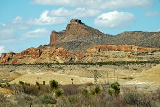 Just after lunch on Monday, Feb 12th we started on an approximate 50 mile loop road in the western part of the park. The first 13 miles (22 km) of the road was dirt and gravel. Since it had rained a couple of days earlier, there were still muddy sections to it and we could see deep ruts where other vehicles had trouble navigating. We were happy we had the high clearance of the truck. The land is stark and we passed badlands and cliffs and deep washes.
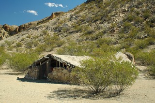 We stopped to see Luna’s Jacal (a primitive Mexican house-shelter). Gilberto Luna, a pioneer Mexican farmer, built this shelter and raised a large family here. He died in 1947 at the age of 108. Luna had farmed this dry Alamo Creek drainage for nearly a century and had peaceful relations with both the Apaches of the area and the Comanche War parties. The jacal at the peak is only about 4 feet high but is about 30 ft long.
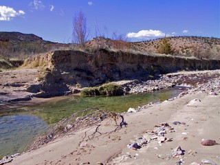 Close to the end of the gravel road we turned off and followed a dirt road to Terlingua Abajo, a deserted farming community. Finally, we found water other than the Rio Grande River. When quicksilver (Mercury) was discovered in 1899, much of the flatlands by the waterways were cleared for farms. This area produced vegetables, wheat and maize for the miners. Water was channelled to the fields by irrigation ditches. When the mines closed so went the farms.
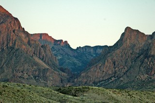
At the end of the gravel road we again reached the Rio Grande River. We crossed Terlingua Creek on stepping stones and headed 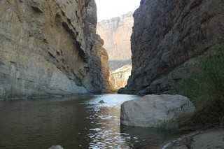 for Santa Elena Canyon which is spectacular! At its mouth the walls tower 1,500 ft. Mexico’s Chihuahua state forms the left wall and of course Texas is on the right. The 17 mile long Terlingua Fault is only accessible by canoe or for about 1/2 mile on a trail. This picture is at the end of the trail looking further into the canyon. The trail is steep and narrow in places but well worth the effort. The canyon was about 15F cooler than the flood plain just before the entrance.
As we looked out over the flood plain from the entrance to Santa Elena Canyon there is little evidence of the fields that once covered this area. In 1914 the land was prepared for irrigated farming with ditches moving the water from the Rio Grande. Cotton was successfully grown here until 1974 when a flood carried the heavy ginning machinery to the bottom of the river.
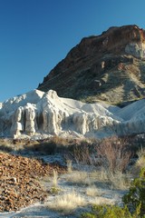
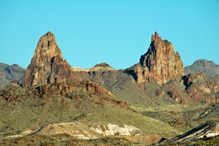
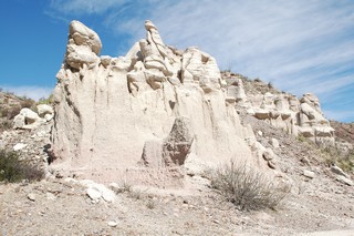
We headed north toward the centre of the park and came upon this white stone outcropping. It is called “tuff”and is actually compressed volcanic ash which has been cemented together by pressure from overlying layers and later exposed by erosion. A little further on are Mule Ears Peaks, again formed by erosion into the shape of mule’s ears. They have long been a traveller's landmark.
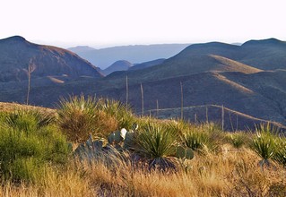
The sun was getting low when we reached Sotol Vista. From here we had a 360 degree view of the park and could see the Santa Elena Canyon 14 miles away, as the raven flies.
It was soooooo quiet up there. No traffic sounds, no trains, no people – just the wind as it blew through the grass and the sotol plants.
As we finished our day ,we drove along the west side of the Chicos Mountains and were able to look into the same window in the mountain that we had looked out of, from Chicos Basin at sunset, the end of the day before. Check out that picture again in the previous journal – Big Bend National Park – Part I.
The next day we visited Big Bend State Park which is to the west of the National Park. Similar landscape as the national park and below are a few of the pictures we took there.
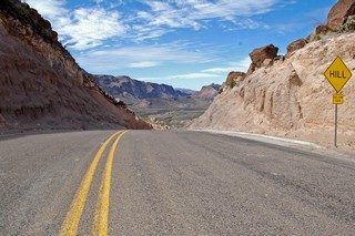
This “Hill” has a 15% grade for close to a mile.
At the top looking down.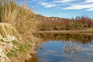
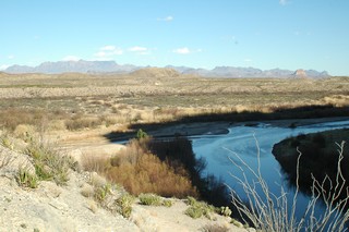
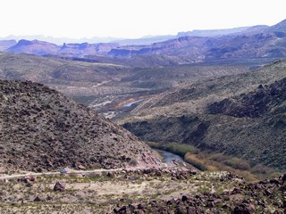
At times the Rio Grande is very beautiful.
More “tuff”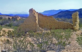
We ended our day with a visit to Terlingua Ghost Town which is now being repopulated by artists and crafts people who have resurrected some of the old buildings.
We remained in Terlingua one more day as the weather at our next destination, Fort Davis, Texas was for freezing temperatures and possibly snow. We went to the golf driving range and hit some balls into the desert. We didn’t play the course as it is a “target course”. You hit from the tee to a patch of grass, over the desert shrub and then hit from there to the green, again over desert scrub. We’re not good enough for that and I don’t think we could afford the lost balls.
Now on to Fort Davis.
Bernie & Ross
Posted by Bernice at February 25, 2007 06:46 PM
Comments
Your journals are fabulous, Bernie. We sure missed out on a very good thing. The Park is emptying out daily. We are celebrating alot of birthdays but by next week and the week after most of our group will be gone.
Take care
Jack and Anita
Posted by: Jack & Anita Riddell at March 11, 2007 10:10 AM
Thank you for sharing your trip with us. I keep asking myself why I am not doing what you are doing. Hopefully, it won't be too long.
Rick
Posted by: Rick Russell at March 11, 2007 01:21 PM
Hi:
Boy, I'm seeing things here that I probably won't ever see. This would be a great trip to take on my motorcycle some day.
Hope everything is well with both of you, it sounds like it is.
Bob Hall
Posted by: Bob at March 11, 2007 09:45 PM
Anita sent me your journal after hearing her say what a great descrpition you gave. I feel I travel with you and want to see it for myself. Please included me in your next report.Bobbi and Gilbert
Posted by: Bobbi at March 13, 2007 12:52 PM
Great run in the south west. We will be doing that run in sept 07 as I will be retired in May
May see you on the road in the fall.
greg C
Posted by: greg colbourne at March 13, 2007 07:31 PM