« New Brunswick 2006 - Sussex Balloon Festival. | Main | Nova Scotia 2006 - the Atlantic Coast »
September 23, 2006
Nova Scotia - from A to A (Amherst to Annapolis Royal)
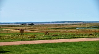 Arriving in Nova Scotia, you pass through farmland that was reclaimed from the vast Tantramar Marsh by the 18th century Acadians, by a series of dykes. We saw similar series of dykes around Grand Pre just outside Wolfville, NS.
The town of Amherst, a centre of wealth and influence, was home to four of the Fathers of Canadian Confederation. 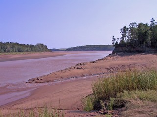 From Truro we took the highway that hugged the water of Minas Basin which is the south east arm of the Bay of Fundy. Just before South Maitland we crossed the Shubenacadie River almost at low tide. The river is huge with wide sand bars and wet silt and is tidal, miles from the bay. We crossed the river 21 miles upstream and at that point you could see that the tides could still rise 20 – 25 ft.
We followed Highway 215 (the Glooscap Trail) that continues along the coast. It is a disgrace to the province of Nova Scotia and is actually dangerous to pull a trailer over. It has patches on patches on patches on patches, huge chunks of the edges of the pavement missing, six inch drops from the pavement to the shoulder in the few places there is any kind of shoulder. It was so bad that unfortunately it made us hesitant to try other similar roads while pulling the trailer.
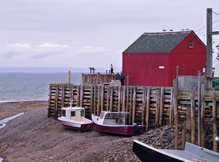
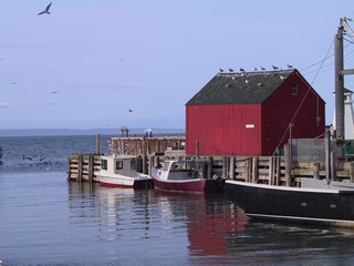
We made our base just south of Kentville at an excellent campground and on Wed. Sept 14th we toured the area. We went to Hall’s Harbour for low tide in the morning and then returned about 6 hours later for high tide. The tides around here are the highest in the world, reaching greater than 30 ft. We took pictures of the same scene at both times.
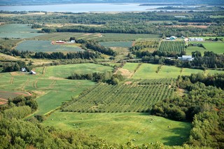
In Ontario we call them "look outs" – in Nova Scotia they are Look Offs and there is a wonderful one just up from Wolfville. The view is over the lush agricultural land of the Annapolis Valley. The valley nestles between South Mountain and North Mountain – ridges that run parallel to the river. North Mountain protects the valley from the winds from the north coming across the Bay of Fundy and Minas Basin. We stocked up on the wonderful produce of the area.
Annapolis Royal is one of the oldest European settlements in Canada. In 1605 the area was settled by a small group of French explorers two years before Jamestown, Virginia, three years before the founding of Quebec, and fifteen years before the Pilgrims landed at Plymouth, Mass. During the 150 year struggle for control of the continent, the area changed hands seven times between the French and English . In 1710 the British captured Port Royal and renamed it Annapolis Royal after Queen Anne. The downtown area is a National Historic District.
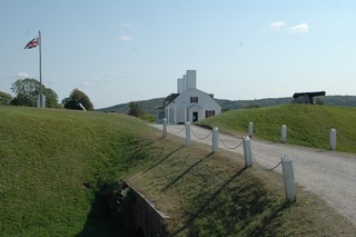
We visited Fort Anne which still has a few of the original stone buildings. It stood guard at the mouth of the Annapolis River which was a gateway into the interior.
We also visited North America’s only tidal power generating station. The huge power of the tides is harnessed twice a day. As the tide goes out, the generating station produces and then feeds power into the Nova Scotia power grid.
We are staying at a campground just outside Digby and I’ll write more about that area in the next journal
Till then – take care
Bernie & Ross
Posted by Bernice at September 23, 2006 11:57 PM
Comments
Hi Ross and Bernice:
Sounds like you are having a great time.
Steve
Posted by: Steve at October 1, 2006 11:44 AM
Hello
Just keep learning more from you about the area. Still writing everything down--we will not have the time you do but your information and pictures are invaluable. Every area looks gorgeous! Looking forward to the next chapter.
Sincerely, Bette
Posted by: Bette Andrew at October 4, 2006 01:30 PM