« August 2006 | Main | October 2006 »
September 30, 2006
Nova Scotia 2006 - the Atlantic Coast
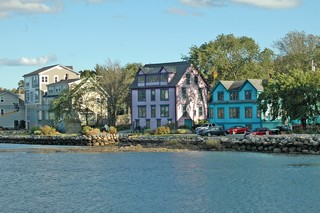
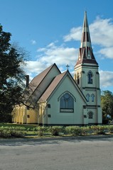
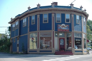
Mahone Bay is a summer area for residents of the Halifax/Dartmouth area. It is a pretty town with well kept homes and all the various shops that one would expect in a resort type village. We spent a whole afternoon wandering in and out of galleries, antique stores, etc. Three Churches greet visitors as they arrive and have stood on the bay since the mid-1800s.
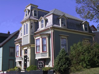 A visit to Lunenburg’s historic downtown is like taking a trip back in time, where dozens of historic buildings and homes dating back to 1760 have been beautifully maintained. In 1995 the United Nations declared Lunenburg’s Old Town area a UNESCO World Heritage Site.
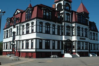
The beautiful Lunenburg Academy was built in1895 at a total cost of $30,000. Like most construction projects it was over budget – by $5,000. It is still being used, today as a primary school.
Lunenburg was the home of the original 1921 Bluenose and also the Bluenose II built in 1965.
The original Bluenose was the undefeated champion of the North American fishing fleet and winner of four international schooner races. Her picture graces the back of our Canadian dime.
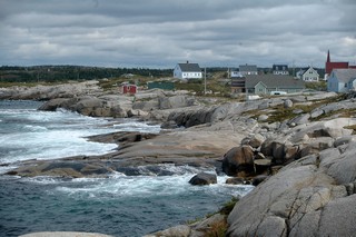
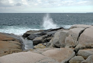
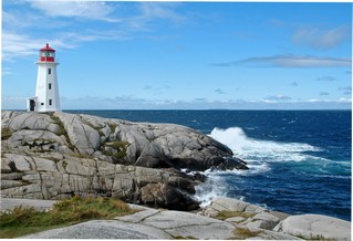 Peggy’s Cove – it’s just as picturesque as we remembered.
The rock is worn smooth from the waves but actually the footing is quite good as the rock surface has almost a texture to it.
The lighthouse is the Post Office in the summer and you can have letters hand cancelled there with a special stamp.
We visited with family while we were in the Halifax area and didn’t really do any sightseeing as we have visited the city a number of times before. Of course, the Citadel is still there looking over Historic Properties and we stopped at the casino to leave our contribution. The Rolling Stones performed for 50,000 fans the week-end we were there.
We are now heading home as we want to be in Cambridge by Thanksgiving. Mandi & Ricardo (and Qunicy later) are coming home from the Bahamas for a visit. Ricky is walking so we are looking forward to seeing him. It seems like a long time since Easter.
We’ll head back via Fredericton and the St. John River valley, so we’ll send one more journal as it’s a very pretty trip.
Bernie & Ross
Posted by Bernice at 05:03 PM | Comments (1)
September 23, 2006
Nova Scotia - from A to A (Amherst to Annapolis Royal)
 Arriving in Nova Scotia, you pass through farmland that was reclaimed from the vast Tantramar Marsh by the 18th century Acadians, by a series of dykes. We saw similar series of dykes around Grand Pre just outside Wolfville, NS.
The town of Amherst, a centre of wealth and influence, was home to four of the Fathers of Canadian Confederation. 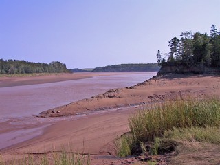 From Truro we took the highway that hugged the water of Minas Basin which is the south east arm of the Bay of Fundy. Just before South Maitland we crossed the Shubenacadie River almost at low tide. The river is huge with wide sand bars and wet silt and is tidal, miles from the bay. We crossed the river 21 miles upstream and at that point you could see that the tides could still rise 20 – 25 ft.
We followed Highway 215 (the Glooscap Trail) that continues along the coast. It is a disgrace to the province of Nova Scotia and is actually dangerous to pull a trailer over. It has patches on patches on patches on patches, huge chunks of the edges of the pavement missing, six inch drops from the pavement to the shoulder in the few places there is any kind of shoulder. It was so bad that unfortunately it made us hesitant to try other similar roads while pulling the trailer.
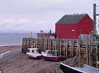
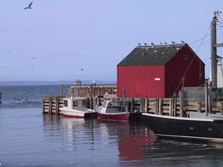
We made our base just south of Kentville at an excellent campground and on Wed. Sept 14th we toured the area. We went to Hall’s Harbour for low tide in the morning and then returned about 6 hours later for high tide. The tides around here are the highest in the world, reaching greater than 30 ft. We took pictures of the same scene at both times.
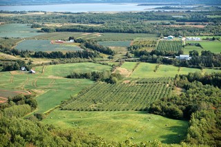
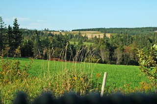
In Ontario we call them "look outs" – in Nova Scotia they are Look Offs and there is a wonderful one just up from Wolfville. The view is over the lush agricultural land of the Annapolis Valley. The valley nestles between South Mountain and North Mountain – ridges that run parallel to the river. North Mountain protects the valley from the winds from the north coming across the Bay of Fundy and Minas Basin. We stocked up on the wonderful produce of the area.
Annapolis Royal is one of the oldest European settlements in Canada. In 1605 the area was settled by a small group of French explorers two years before Jamestown, Virginia, three years before the founding of Quebec, and fifteen years before the Pilgrims landed at Plymouth, Mass. During the 150 year struggle for control of the continent, the area changed hands seven times between the French and English . In 1710 the British captured Port Royal and renamed it Annapolis Royal after Queen Anne. The downtown area is a National Historic District.
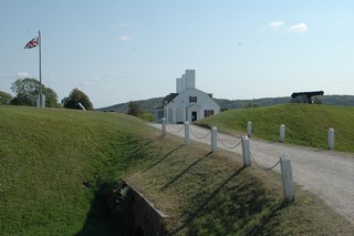
We visited Fort Anne which still has a few of the original stone buildings. It stood guard at the mouth of the Annapolis River which was a gateway into the interior.
We also visited North America’s only tidal power generating station. The huge power of the tides is harnessed twice a day. As the tide goes out, the generating station produces and then feeds power into the Nova Scotia power grid.
We are staying at a campground just outside Digby and I’ll write more about that area in the next journal
Till then – take care
Bernie & Ross
Posted by Bernice at 11:57 PM | Comments (2)
September 15, 2006
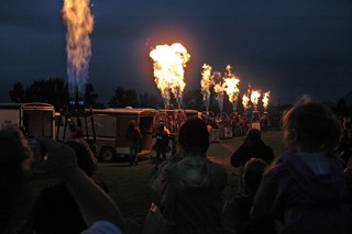
New Brunswick 2006 - Sussex Balloon Festival.
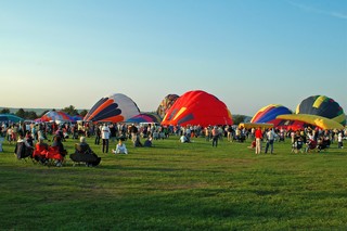
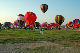
The town of Sussex, half way between Moncton and Fredericton hosts a balloon festival each fall.
Fortunately, on the Friday night the balloons were able to lift off, even though there was more than an hour’s delay until the wind died down.
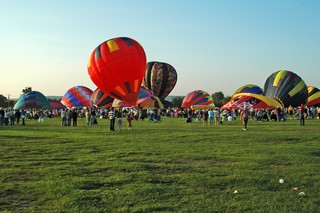
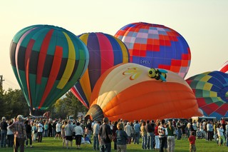
As the burners are fired to start filling them with air, the balloons seem to rise like some huge animals rousing from their sleep.
The first one is in the air!
There is really no control over where the balloon goes. The pilot can control how high or low, by adjusting the flame and that does give a little measure of direction – but the chase cars have to go after them as they don’t land in a particular spot.

This one is called Honey Bear
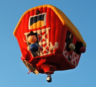
This one is Old MacDonald's Farm
They come in every colour and pattern and as you can see even some very special shapes. The participants come from all over North America for this festival. It is apparently the last one of the balloon season.
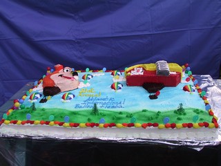
After the balloons took flight there was a huge cake – at least 3’x4’ – served to everyone.
There was also an excellent craft exhibit building as well as carnival rides and games and other exhibitors.
Unfortunately, Saturday evening a storm blew in just at the time that the balloons should have taken off so they didn’t have a flight. They did however have a “burn” after it got dark and the rain had stopped.
We were all able to see the baskets and burners up close. It’s amazing how much heat those burners put out.
We’re taking a couple of days off – going over to Shediac to meet RV friends who have been on Newfoundland all summer. We’ve been busy so it will be nice to stop for a couple of days and do nothing.
After that we are headed into Nova Scotia.
‘Til then
Bernie & Ross
Posted by Bernice at 09:46 AM | Comments (4)
September 10, 2006
Prince Edward Island 2006 - Part II
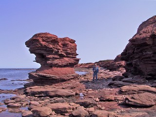
If you look at Prince Edward Island on a map, you will see that it is crescent shaped and nestles at the bottom of the Gulf of St. Lawrence. The north west point is called North Cape and is rugged red rock sculpted by the ocean. Twice a day the tide moves in and out carving the landscape.
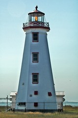
The North Cape lighthouse was built in 1866 and is one of 50 lining the coast, although only about half are fully operational now.
On the south eastern point on the island, at Cape Bear lighthouse, Thomas Bartlett was the first to hear the Titanic’s distress signal as it sank off Newfoundland.
The south east coast still has the red soil, which is caused by iron that has rusted, but the waves do not seem to have the same power and thus the sculptures are nowhere as dramatic.
In a province of such beauty, it sounds strange to say, but after awhile, one red cliff starts to look like another.
We stayed at St. Peters, in the north east of the island, while we toured the east side. We went through road construction (a new bridge) at the Midgell river. The following day we found out that the road had been closed and we had missed a 17 km, dirt road detour by a couple of hours.
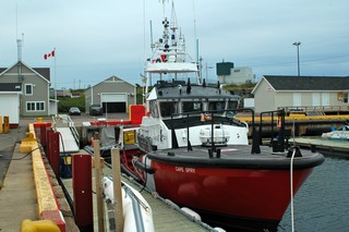 At Souris (pronounced Soo-ree) we were fortunate to meet a member of the Coast Guard Search and Rescue. Of course it didn’t hurt that he was a rail fan like Ross is. Souris is one of their bases in PEI and we were given a full tour of the cutter. The bridge is so full of instrumentation that it is tight quarters to move around. They have all the equipment on board to help stabalize and tow vessels in distress and to retrieve people from the ocean. Most interesting.
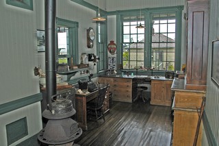
At its peak, the PEI railway system had 121 stations, along 400 kilometres of track. It connected almost every village on the island and ended at the Elmira station in the north east. The station has its original furnishings and is very well maintained. There has been no railroad on PEI for around 20 years, but the Confederation trail follows this abandoned rail line. It’s a wonderful bicycling and hiking path that traverses the 280 kilometre-long province. The trail includes a network of unsurfaced paths branching from the interior to the coastal areas. We hiked the trail on a number of occasions as it went right past both campgrounds we stayed at.
We didn’t spend much time in Summerside or Charlottetown but did go in one rainy day to tour Province House. This was the site of meetings that led to Canada’s confederation in 1867 and the Provincial Legislature still meets there. It’s worth a visit.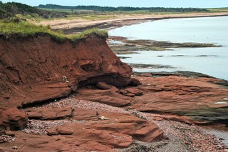
We decided that one business we would like to have on the island would be riding mower sales & service. Generally the houses are modest but the lawns are HUGE and every one is cut beautifully and well maintained.
Rugged coast lines with sandy beaches, rolling hills, fields and fields of potatoes, woodlands and long bays. It’s a gentle island and we were always made to feel welcome.
We’re headed to Sussex, New Brunswick for the balloon festival Sept 8, 9 & 10th.
Pictures from there in the next report.
Bernie & Ross
Posted by Bernice at 11:59 AM | Comments (1)
September 06, 2006
Prince Edward Island 2006 - Part I
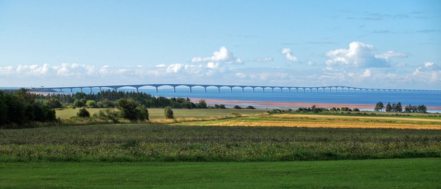
The Confederation Bridge joins Prince Edward Island to the mainland of New Brunswick. Built in 1997, the 12.9 kilometer (8 mile) span is the world’s longest over ice-covered waters. There is no charge to go over to the island – but – the fee is $40.50 plus $6.75 per axle over 2, when you decide to come back. Of course you could take the Wood Islands Ferry to Nova Scotia, but that costs more and certainly takes longer.
We stayed at a campground – “Sun N Shade” – just a few kilometers from the bridge and toured the central and western sections of the island using it as our base. Six nights a week there is music in the campground hall, bluegrass, gospel and traditional and then after a break they have “open mike” when musicians from the audience come up and perform with the group. The musicians are the husband and wife owners of the campground and were absolutely excellent.
I am going to let pictures do a lot of the journal in PEI. The scenery is magnificent and the red of the soil adds striking colour to so many of the landscapes.
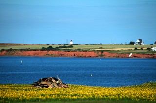
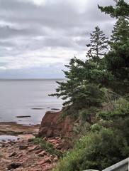
Clear blue water edged by red banks with a lighthouse in the background is the typical picture of Prince Edward Island. However there is sooooo much more.
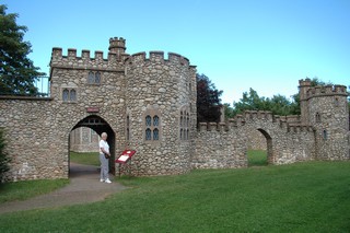 Outside Kensington we visited Woodleigh Replicas, a 45 acre site that features 30 large scale models of castles and cathedrals from the British Isles. Most are not as large as this one, but the details are just as great on the smaller buildings. The work was done by one man assisted by his family. A fascinating couple of hours!
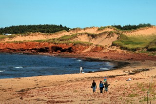
Cavendish Beach is part of the PEI National Park that extends 40 km (25 mi) along the northern shore, on the Gulf of St. Lawrence. Long sandy beaches, huge sweeping sand dunes, ponds, woods and salt marshes draw thousands of summer vacationers.
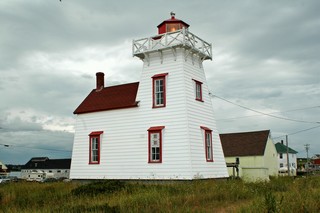
North Rustico Harbour lighthouse was built in 1876 and is still in operation. North Rustico and New Glascow both have famous Lobster Suppers. We went to New Glascow and had an excellent meal, although they are not cheap – about $65.00 plus drinks, for the two of us.
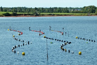
Thousands of coloured floats in the mouths of the rivers of PEI turned out to be mussel farming. The colours of the floats indicate the owner of the strings. The mussels are harvested when they have matured and are served in every restaurant that we ate in.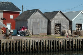
Everywhere are small harbours with the fishermen’s sheds close by. The lobster season doesn’t start again until around November so the traps are stored neatly till then.
We are seeing the island from one end to the other, North Cape to East Point. We have now seen the centre portion and I’ll send the next journal with pictures from both ends of it.
Bernie & Ross
Posted by Bernice at 05:54 PM | Comments (1)