« February 2006 | Main | August 2006 »
March 31, 2006
New Mexico to Home
 As we headed east the land is still striking with flat plains interrupted by coloured cliffs and buttes. The weather was getting colder and from Albuquerque we headed north east to Santa Fe, the capital of New Mexico. It, at 7,000 feet, is nestled in a valley between the Jemez and Sangre de Cristo mountains ranges with peaks rising to 12,000 feet.
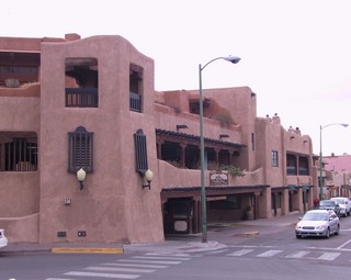
The Spanish arrived in Santa Fe in 1607 and it is considered to be the second oldest city in the United States. The buildings look Spanish-Pueblo and apparently years ago the city enacted legislation to set the appearance of any new construction. Buildings, including fast food restaurants and convenience stores must be painted in the various shades of brown that are sanctioned and they must also conform to the traditional adobe style. There is also a height limit. The building to the left is a perfect example – it’s a parking garage.
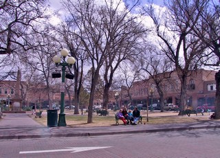
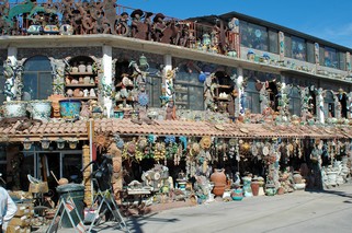
We walked around the square which has been the centre of Santa Fe since its founding. It still is a centre of commerce, festivals and history and although it was quite a raw day while we were there ( it actually snowed later) there were many families and visitors there. Surrounding the plaza are many galleries with pottery, silver and turquoise jewelry and other quality southwestern art. Along one side numerous native artisans sold their crafts. We will definitely come back to spend more time here, but we will try to make it when the weather is better.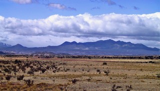 We left Santa Fe and the beautiful Sangre de Cristo mountains on a sunny but chilly Monday morning, March 20th and headed further east on I-40 across the Texas panhandle.
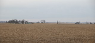
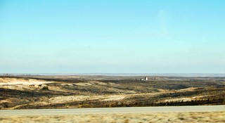 The second day brought us into the area where the wildfires have been this winter. About 10 days before we went through the area near McLean TX, the highway had been closed because of the fires around it. The Interstate obviously acts as a fire break as the burnt area came right up to the north side of the road but the south side was (in general) untouched.
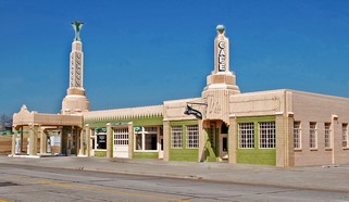 We have been following the old Historic Route 66 since we turned east at Flagstaff, AZ. It was the original highway from Chicago to Los Angeles and was the main street of most of the small towns that we have been passing. We have gone off the interstate on a number of occasions to follow Rte 66 and have found most of the towns in decay. The bypass by the interstate killed so many of the businesses that depended on the traveller. Occasionally, however we found wonderfully preserved examples of the architecture of the day. This former service station in Shamrock TX now has a second life as the Chamber of Commerce.
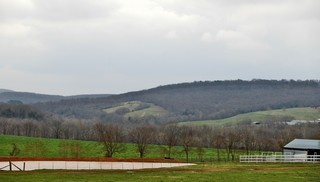 Our next destination was Branson, Missouri so we headed across Oklahoma, through the corner of Arkansas to the south east section of Missouri. We have been in green all the way through the rolling terrain of Oklahoma. Branson is in the Ozark mountains, which are the oldest on the continent, and are more like very large heavily wooded rounded hills.
Branson is the newest live entertainment destination on the continent. It wasn’t until the early 90’s that growth really took off. We were talking to a “local” and the town used to be 3,500 – it now has 6,000,000 visitors a year. It has at last count 47 theatres that produce shows encompassing country & western, comedy, dinner shows, acrobatic acts and illusioinists. There are all types of restaurants available and dozens of family entertainment venues such as mini golf and go-carts. The city is built on hills and has a great road system with Blue, Yellow & Red routes that keep you away from the absolute traffic jam on the “strip”, Hwy 76, the main street where most of the theatres are.
We went to two shows. One was Pierce Arrow, a fabulous musicical show with a good supply of comedy included. I laughed so hard I actually had tears running down my cheeks. The other show was Dolly Parton’s Dixie Stampede which was a dinner show where we ate the entire meal with our fingers. We were in an arena and during the meal, horses and riders did trick riding, barrel racing and chuck wagon racing. There were ostrich races and racing pigs. We had a ball and the food was great!
 We left Branson on Sunday, March 26th and headed home. The road took us past St. Louis, MO, through Illinois, around Indianapolis IN, through Flint MI and across the border at Sarnia, ON. The land is very much like south western Ontario and we have been through this area a number of times before so we didn’t stop to sightsee.
We took 4 driving days to cover the almost 1,000 miles from Branson. We have decided that in general we do not like travelling more than 250 miles (400 kilometers) in a day. The crossing at Sarnia was uneventful and after a stop in London, we were at the campground in Waterloo by about 5PM.
It’s good to be home, but we will be on the road again sometime this summer – not sure exactly when. Mandi & Quincy are coming home for a visit at Easter, with our grandson Ricardo and will be staying with Michelle. As you can imagine we were glad to see Shell & Barn when we got here, and look forward to our time with all our family.
We have had a good trip (just under 19,000 km) this winter and hope that you have enjoyed the journals. We’ll keep in touch and you’ll hear from us when we are on the road again. If you are planning to travel and would like more detailed information about any of our destinations, please send us an e-mail or give us a call at 416–436–7232. We’ll be happy to share what we have learned with you.
Till then, keep well, enjoy every day and smile.
Ross and Bernie
Posted by Ross at 05:58 PM | Comments (2)
March 20, 2006
Arizona - Part II
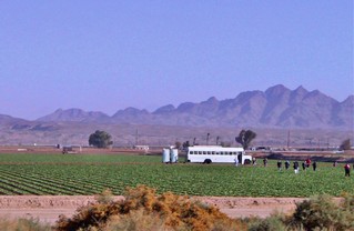
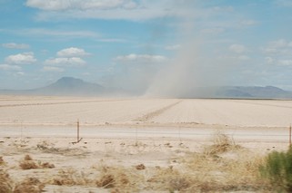
East of Yuma we finally found significant agriculture and after the dry of the past few weeks it was a welcome sight. But the green is the result of massive irrigation, while dust storms rage on the land where the plants have not sprouted. In fact, there are warning signs on the highways about reduced visibility because of blowing dust. We found it interesting that the field workers come in by a bus which also pulls two portable toilets for them.
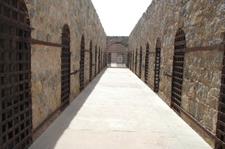
Yuma Territorial State Prison, built by the earliest inmates in 1876, was known as “the Hell Hole of Arizona” and was used as a prison until 1909. I can’t imagine how hot is must have been in the tiny cells in the Arizona summer. The prison was the setting for Steve McQueen’s original 50’s TV series “Wanted Dead or Alive”. It sat at the confluence of the Gila and Colorado Rivers and looked out over the flood plain.
Yuma has warm dry winters and because of this “snowbirds” descend on it, keeping over 70 RV & trailer parks busy.
Yuma is on the California border just north of Mexico and is as far west as we are going on this trip. We headed 80 miles north through the Yuma Proving Grounds where the army stages tank battles and other tests of military equipment, to Quartzsite, which is another area that feels the influx of snowbirds. Literally hundreds of thousands of RV-owners descend on the area in January and February because of the rock and gem show, RV show and Sell-O-Rama (a huge flea market), held then. Escaping the northern winters also is a major draw and they dry camp (no hookups) by the thousands in the desert around the town.
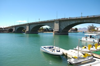 On Sunday, the 12th, we drove up to see Lake Havasu which is about 70 miles further north and was created by the damming of the Colorado River. A most unusual sight – London Bridge – spans a channel, which was dug so that the bridge would have something to span. R. McCulloch (the chainsaw manufacturer) bought the bridge in 1967 and had the 10,000 numbered blocks of granite shipped from London, across the Atlantic and put back together here. The bridge now ranks second among Arizona’s tourist attractions, after the Grand Canyon.
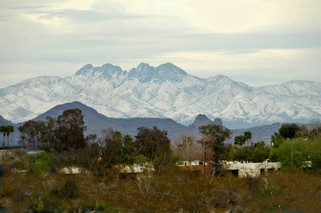
While we were in Quartzsite, a major storm came across the area dropping up to 2 feet of snow in the mountains and significant rain at lower elevations. The rain on March 11th broke a dry spell of 143 days and the excitement on the radio and TV was amazing. We in Ontario take the rain for granted & forget sometimes how important it is. On Tuesday March 13th we turned east from Quartzsite to Phoenix. The mountains to the east of the city were beautiful, covered by the new snow. Ross took me out for lunch on the 14th, my birthday, to a great restaurant called “Wildflower”. If you ever get a chance – go!
Both of us found Phoenix to be a very impressive city with wide clean streets and wonderful views of the mountains. The majority of the houses do not have lawns as the landscaping is desert plants and trees and no grass. It makes for a totally different look in the residential areas.
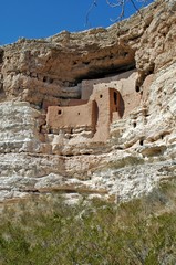 After a couple of days, we continued north and stayed for two nights in the parking lot of Cliff Castle Casino just north of Camp Verde. The first afternoon we visited Montezuma’s Castle, a pink adobe cliff dwelling that was originally reached by 3 separate ladders from the valley floor. The sycamore beams are apparently still in place, and the fingerprints of the Indian masons are still visible on the bricks, but visitors are not allowed to climb up. It is believed that this dwelling is over 700 years old and no one knows why it was abandoned.
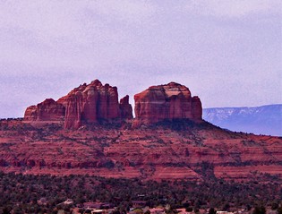
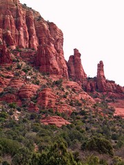
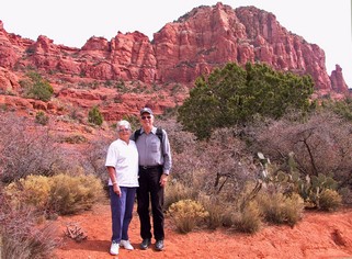
The next day we went to Sedona. As you drive toward it through Oak Creek the red cliffs overpower you. The town is quite neat with high class (read expensive) shops. We even found another Wildflower for lunch!
I’m going to let the pictures of the area speak for themselves.
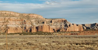
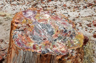
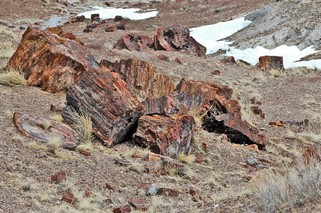
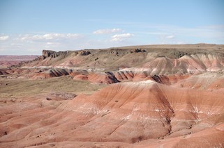
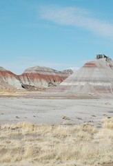
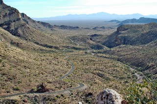
We left our contribution at the casino and headed north and east past Flagstaff to Gallup, New Mexico. We didn’t take the time to go further north to the Grand Canyon as we have visited it twice before. We did drive through the Petrified Forest and Painted Desert which is only a short detour off I-40. Apparently petrified wood is found in every state, but the sheer abundance of it in this area of Arizona is extraordinary. The trees date back 225 million years and didn’t originate here but accumulated like a log jam in an ancient river. Bit by bit, buried in layers of silt and ash, silica seeped in to the original wood cells and crystallized into quartz. The colours are amazing.
Leaving the Petrified Forest you drive through the Painted Desert, a poorly defined area of multi-coloured badlands that covers much of northeast Arizona. It supports little vegetation or life of any kind and continues to erode at a fearsome rate.
We stopped just inside the New Mexico border that evening and will head toward Santa Fe tomorrow.
Posted by Ross at 07:22 PM | Comments (1)
March 10, 2006
To Mexico & back
 We headed west and stopped for two nights in Gila (pronounced HEE–la) Bend.
There are some striking rock formations in southern Arizona. They rear up from the flat plain and are really piles of rock rubble– mind you, BIG piles of rubble. In general the roads go around them.
We finally made the decision go south into Mexico. We have never been there before and really don’t know what to expect but in talking to other RVers everything sounds fine, especially in the area we are headed to.
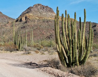
On the way south, we visited Organ Pipe National Monument which is just above the Mexico border. The name comes from a type of cactus, which looks like church organ pipes, like the one shown.
When going into Mexico you need Mexican vehicle liability insurance. They don’t check anything at the border but if you are stopped or have an accident and can’t produce the certificate you will probably go to jail and your vehicle will be confiscated. We obviously bought some. You can buy the insurance at the border, at gas stations, convenience stores – just about anywhere. It was $56.00 for 10 days coverage.
As we were not going further than the “free zone” we didn’t need a visa or visitor’s permit. The “free zone” is a defined distance from the border and includes designated tourist areas and access routes. The crossing was easy, they just waved us through and didn’t even look at our passports.
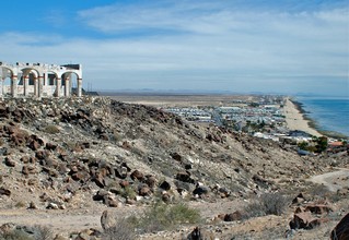 We stayed on the south side of the town of Puerto Penasco which is about 100 km south of the US border, right on the Sea of Cortez (the water that separates mainland Mexico from the Baja Peninsula). It is a very Americanised community where English is spoken most everywhere and the US dollar is accepted readily. The exchange is usually 10 pesos to $1.00. Our campground was right on the ocean although our site was back a bit. This picture is from the top of a hill between our campground and Old Port looking down at the beach (the right edge of the picture).
The land is very flat although there are hills of rock that rise from the plain like islands. This is very similar to southern Arizona. It’s dry here. We thought that Arizona was dry but this is even more so. The only place you see vegetation of any size is along the washes where the water accumulates when it does rain.
One day we travelled about 60 km south of town but finally turned around at a police checkpoint as the next community was still a further 50 km and there was nothing but desert to see.
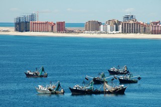 Puerto Penasco is exploding with construction – hotels, condos, high end houses – but it is still a fishing village with the shrimp boats going out every day. There is a wonderful harbour and across it, outside of town, is Sandy Beach which is now lined with expensive condo timeshare resorts. The town itself is a combination of the old and the new. The older area – Old Port – has had a lot of upgrading done to streets and public areas. The areas outside Old Port are a mixture of wonderful new homes right beside plywood shacks. The construction on the buildings never seems to to be finished and we found out that is because taxes become payable on completion.
 We enjoyed our stay, had lots of Mexican food, wandered the markets, walked along the beach, took a resort sales tour (they paid us $100 and a free lunch) and enjoyed the warm weather and sun. The water in Puerto Penasco is fine to drink so no problem there. It averaged about 75 F in the day and cooled off nicely in the evening.
All gas stations are Pemex and state owned. Mexico uses the metric system so the gas was priced by the litre – 51.3 cents. WOW! We plan to go back and travel further into Mexico the next time.
Now we are heading back to the US and our next destination is Yuma in the very south west corner of Arizona. We’ll backtrack through Gila Bend as we have been advised by locals that the Mexican highway along the border is not very good for RVs. Better safe than sorry.
Bernie & Ross
Posted by Ross at 04:06 PM | Comments (1)