« June 2005 | Main | August 2005 »
July 30, 2005
Northern Washington
Remember back when we were coming through Ontario, Manitoba, North Dakota, Montana and into Yellowstone? All we had was rain and cold. Well, other than about an hour of drizzle just before the Redmond rally, we have had wonderful weather since then. The central valleys of California, Oregon and Washington are quite hot in the daytime but cool off beautifully in the evening. We have only used the air conditioning a couple of times – I think it was in Chico – to cool the trailer down from the high daytime heat. I guess our decision to go south into Idaho and on from there was the right one!
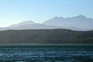 When you look at a map of Washington state you will see Puget Sound dips way down to create the Olympic Peninsula to its west. The Sound itself has a large peninsula coming up into it – the Kitsap. We set up camp at Potlatch State Park on the east side of the Olympic Peninsula looking across the Hood canal at the Kitsap Peninsula. (Hope I’ve got everyone going looking for their maps to see where we are) The Olympic mountains to our west are quite different from those that we have been seeing for the last few weeks. These are rocky, rugged and much more angular than the tree covered rounded ones of western Oregon and Washington.
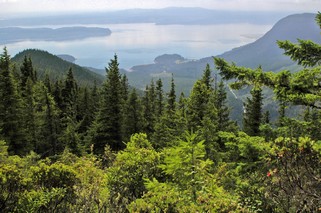
One day we decided to go to Seattle across the Kitsap and then by ferry. On the way up to the Hood Canal bridge we took a side trip up Mt. Walker. It was a 7 km gravel road to the 2,804 foot summit. A lot of the last 3 km was one lane, with pulloffs every so often in case you met someone. Fortunately, we only met one car and we were right at one of the pulloffs. The view was wonderful with panoramic views of Puget Sound, the Olympics and the Cascades. Unfortunately, there were a lot of clouds over the Olympics so we only caught glimpses of them.
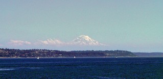
As we travelled east on the ferry toward Seattle, Mt. Rainier towered over the landscape. At 14, 411 feet it is 249 feet higher than Mt. Shasta in California. We were wrong about Mt. Shasta, it is the second highest mountain in the lower United States not North America. Mt. McKinley in Alaska is higher than both Rainier or Shasta. These volcanic mountains are very impressive as they stand alone, high above the other mountains in the area. (It’s the white cone on the right, the rest are clouds)
Seattle’s historic district has been restored beautifully and Pike’s Place Market which opened as a farmer’s market in 1907 is now very diverse and interesting. While in the Seattle area, we went out to Redmond WA (a suburb ) to drive around the Microsoft campus. And that is what it looks like – no huge buildings, just lowrise buildings in a setting reminding us of a college campus. Even the parking lots were shaded with lovely trees.
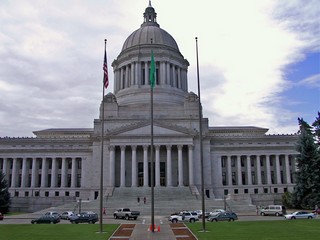 Olympia, at the south end of Puget Sound is the state capital and we took a tour of the legislative buildings. The building was completed in 1928 and the whole of the interior of the ground and first floors have been constructed of black and white Alaska marble. WOW! The Senate and House chambers are European marble which was brought back as ballast on troop ships during World War 1. The lighting fixtures in the whole building as well as the chandelier that hangs in the rotunda were designed by Louis Comfort Tiffany. The building has a 287 ft masonry dome, one of the largest in the world. This is probably the most impressive state capital we have seen – and we now have seen them all except Alaska & Hawaii.
We packed up on Sunday morning, July 24th and headed around Puget Sound expecting the traffic to be relatively light. No such luck – you would have thought that it was a weekday rush hour as we passed Seattle, and we took the bypass.
Our final location in the U.S. was Mt. Vernon just 60 miles north of Seattle and 55 miles south of the border. As you can imagine, when we arrive in an area and turn on the television, we have no idea what station we may be tuning in to. In Mt. Vernon, the first TV station we turned on had a Tim Hortons’ commercial. We knew we were close to Canada! It’s amazing how different the U.S. commercials are from Canadian. We got so tired of being bombarded by medical commercials with all their “cover your backside” disclaimers. What a pleasure to hear about coffee.
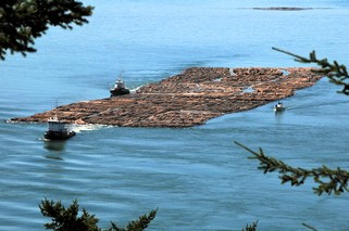 We did go sightseeing to the islands just west of Mt. Vernon. On a huge bridge over Deception Pass (passage)we watched two tugs maneuver a huge log boom through the pass. One tug pulled the boom and the other would push or pull the end of the boom to give it additional direction. We tried to calculate how many logs there might be and later learned there could be as many as 5 to 10 thousand logs (trees) in one log boom.
Standing on the bridge we could look directly west and see land. It was Canada, in the general vicinity of Victoria. Even with binoculars it was too hazy to make out details. On the way back to camp, we went though some wonderful market gardening areas. We also made a quick stop at the Casino – it should have been quicker – to leave our contribution. Well, actually Bernie came out $4.00 ahead.
On Wednesday we will be heading home to Canada. We’re glad. It’s been a wonderful trip so far and we have met and made friends with some great people. However, it will be nice to be back with familiar stores and products, Canadian money and Tim Hortons.
Ross & Bernie
Posted by Ross at 06:06 PM | Comments (0)
July 28, 2005
Southern Washington
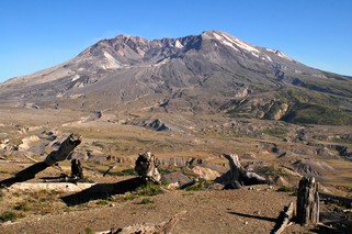
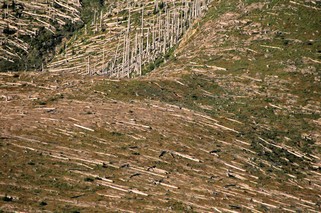
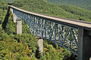
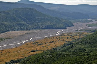
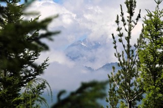
Mount St. Helens – a National Volcanic Monument. On May 18, 1980 just after 8:30 AM, a magnitude 5 earthquake, centered beneath the north flank, shook the mountain and triggered an avalanche, and the whole north side of the summit started to fall away. In minutes, the 9,677 foot summit was reduced by 1,300 feet. The cloud from the eruption rose 12 miles into the atmosphere. 500 million cubic yards of molten rock were blasted from the mountain and plunged into Spirit Lake and the Toutle River at speeds of 150 mph. An enormous blast cloud tore out of the mountain and surged at several hundred miles per hour, hugging the ground and climbed over four major ridges and valleys. It levelled 230 square miles of prime forest and killed almost everything in its path. This whole sequence took less than 5 minutes. In the next hours, ash and pumice flows swept out of the crater and down the mountain. This was followed by mud flows of ash, fine rock mixed with snow and ice which raced down rivers, sweeping bridges and homes away. Spirit Lake’s water level was raised 200 feet. The Toutle River valley was filled with rock and debris to depths of 300 feet, completely covering the original road to the mountain. 57 people died and an estimated 1.5 million animals. A new road has been built with 19 new bridges (the one pictured above is 2600 feet long), this time high up on the sides of the approaching mountains. The land is gradually starting to recover, but some areas closest to the blast have only bits of lichen and grass even yet. Massive reforestation efforts started immediately – Weyerhauser lost 85,000 acres of trees. The National Monument has however been left to natural recovery.
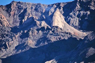
And the mountain is once again stirring. Since March of this year, a lava cone inside the crater (see second picture) has been growing at about 5 feet per day.
Perhaps, because this eruption happened in the very recent past, rather than thousands of years ago like so many other things we have seen, it had a very moving effect on both of us. It is very sobering and humbling to realize the awesome power of nature.
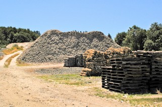
The next day, July 20th, we went to the Washington coast, to Long Beach Peninsula. Going south on the coast from Raymond we went into some of the small villages where oysters were being harvested. There are huge piles of white oyster shells that reminded us of snow – but it was about 25C.
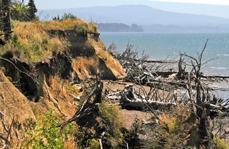
We continued south on a more local road, right beside the ocean. Unfortunately, most of the time you can’t see much, as the trees have grown up between the road and the water. We did however, find an open area and parked to have lunch. Bernie often packs salads so that we are not dependent on finding a restaurant. We have a plug-in cooler that we take with us when we are on a day of sightseeing. The coast is very eroded, with many trees that have been undermined by the surf and fallen to the beach.
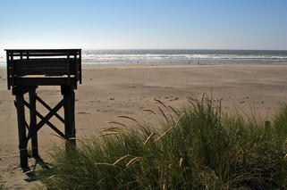
Long Beach Peninsula is a 28 mile spit of land running north from the mouth of the Columbia River parallel to the shore we had just travelled south on. It is known for its oyster farming and its hard sand beaches. There is a wonderful 2,300 ft boardwalk along part of it. In this picture, those tiny dots at the edge of the water are really people, so you can see how huge the beach is. It is also a favourite for kite flying, and in many places the cars are driven right down to the waters edge. Bernie walked way out on the sand so that she could actually stand in the Pacific Ocean.
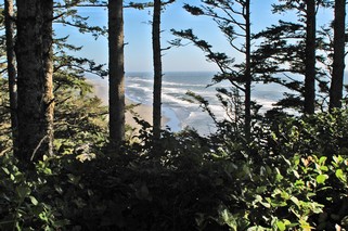
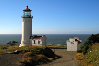
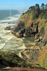
South of Long Beach, at the mouth of the Columbia River stand two lighthouses, North Head and Cape Disappointment. We climbed to the top of North Head. You can see how rugged the coast is looking north. It’s hard to believe that just a few miles further up is Long Beach. Then you look south and you can see the long sand spit of beach that has been created by the flow of the Columbia River.
We came back to our campground at Toledo, WA following the north shore of the Columbia River. A long day, but worth it.
Now we are heading up into northern Washington.
Ross & Bernie
Posted by Ross at 09:03 AM | Comments (0)
July 25, 2005
Nothern Oregon
5 days; 5,612 registered RVs holding about 12,000 people; another1,000 daily admissions; over 1,000 RVs on display and about 500 indoor exhibitors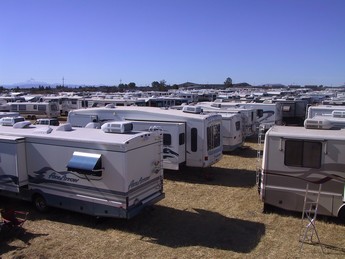 ; the Redmond School Board buses hired to shuttle registrants from the RV parking areas; headliner entertainment in the evening – Debbie Reynolds, Pam Tillis, Ronny Milsap; about 100 different seminars on everything from “Fundamentals of Trailer Supension Systems and Brakes” to “99 days to Panama”. The Redmond, Oregon RV rally was quite a spectacle.
We were in parking area “H” which was really a farm field, complete with 8” grain stubble and dust and was about 4 miles from the fairgrounds where the activities were. There were about 700 RVs where we were and the organization getting everyone in and later out was outstanding. In fact, we were very impressed with the efficiency and organization of the whole rally. Bernie took this picture standing on the roof of our trailer.
We arrived on Sunday July 10th, around noon and left Friday morning. This was the test for our solar system as we had no hookups for the 5 days. It worked wonderfully and we were able to have all the comforts just as if we had been plugged in.
By Thursday evening we were exhausted, as we usually went for the morning seminar at 8:30 and didn’t come back until after the evening entertainment. It was well worth the time spent as we learned so much and saw and heard so many new ideas both in the seminars and at the exhibits. I don’t know if we will go to next years rally – it’s in Daytona, FL in April – but we definately will go to another at some point.
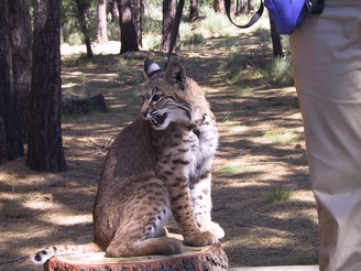 After we left the rally we went back south of Bend to the High Desert Museum. It is a natural museum set outside among the trees as well as some wonderful indoor displays. The rangers brought a bobcat out to the one of the outdoor displays and gave a short talk about it as well as answering questions. We spent the whole day at the museum. We spent the night at the WalMart parking lot in Redmond as all the campgrounds were full because the rally was just over.
We are now heading north so that we will be in Vancouver on July 30th as we have reservations to leave on a 7 day cruise to Alaska. But there is much to see on the way.
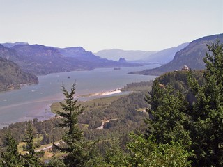
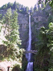
These pictures were taken in the Columbia Gorge. The Columbia River at this point is the border between Oregon and Washington. Some of the waterfalls are spectacular. This one is Multnomoh Falls and is over 600 feet high. You can see a foot bridge part way up that crosses over the water. The view of the falls from the bridge is quite impressive but is too close to get a good overall picture.
We are heading now to Washington. This is the final state in the contiguous United States that we have yet to visit. Most of the others we visited with our daughters when they were teenagers.
Ross & Bernie
Posted by Ross at 11:15 AM | Comments (0)
July 20, 2005
Southern Oregon
As we headed to southern Oregon on July 1st, we passed huge herds of cattle – mostly black angus. The grass is very lush and irrigation of the grazing land is common. From the flat valleys we started up again into the hills following I-5 over Siskiyou Pass, through Ashland and Medford to Rogue River, a popular summer destination.

Since this was the 4th of July weekend, we had made reservations at a campground to be sure we had a spot. The campground was right on the Rogue River and had tables and chairs on the dock. A very nice setup. There were only 25 sites and they were an extremely friendly group, coming over and introducing themselves when we had set out our chairs.
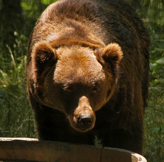 On Saturday, having been fortified with fudge and raspberries at the Grant’s Pass farmer’s market, we drove out further into the countryside and stopped at Wilderness Images. It is a conservation organization that rehabilitates wild animals that have been injured or abandoned and reintroduces them back into the wild. A 1 1/2 hour tour with a guide explained what they do and showed some of the animals that they have. The ones you see can not be reintroduced into the wild due to a number of reasons. They may have an injury or they may have become imprinted by humans and would not survive. We saw 2 grizzilies (finally) (brother and sister), mountain lions, black bears, wolves, otters and up close, a bald eagle, a golden eagle, a turkey buzzard and a great horned owl. The animals that are going to be reintroduced have minimal human contact and are nowhere near the public areas. This is a private facility and survives on donations and private sponsors.
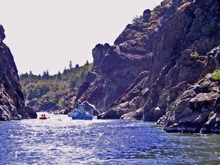
Monday, July 4th was not only the U.S. Independence day, it was also our 41st wedding anniversary. We celebrated by going on a Rogue River Hellsgate Canyon Jetboat trip. We went 18 miles up the river into this beautiful lava canyon, had a wonderful lunch and returned to the campground to celebrate the 4th with a potluck supper on the river. All we seemed to do that day was eat! The neighbours on the river have a competition each year to see who puts on the best fireworks show, so we had front row seats.
We are gradually heading to Redmond to the RV Rally that is being held there. We’ll be checking in next Sunday, July 10th . On the way we stayed at Collier State Park which is on the east side of the Cascade Mountains – so – back over another mountain pass.
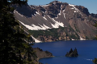 With our base at the park, north of Klamath Falls, we toured Crater Lake. The lake was formed when ancient Mount Mazama erupted and collapsed into itself 7,700 years ago. It is 1,943 feet deep (deepest in United States) and is filled with rain and melted snow and there is no inlet or outlet. The colour is the most startling blue and the lake, about five miles wide, is ringed with 2,000 foot cliffs. One of the Islands (it’s there in the picture) is called Phantom Ship and was formed by subsequent eruptions that have now eroded into a ship shape.
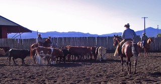 As we came back from Crater Lake we saw a field full of horse trailers so went to investigate. Turned out to be the Fort Klamath Cutting Championships. We spent a couple of hours watching the most amazing horses and riders as they separated (cut)specific calves from the herd.
Now, we’re on our way to Redmond to the RV Rally.
Ross & Bernie
Posted by Ross at 02:51 PM | Comments (0)
July 14, 2005
Nothern California
When you leave Reno, Nevada on Interstate 80, the way to California is over Donner Pass. The elevation at Reno is 4,490 and at the pass is 7,912. That certainly put the truck to the test with a rise of 3,500. As important, the downhill slope into California begins with a sign – “40 miles downgrade.” There are about 33 truck advisory signs along the descent. We were glad when we got down into the valley and on to Sacramento.
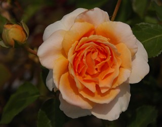 The next day we went downtown and took a tour of the Capital buildings. We didn’t see Arnold (Schwartzenager) although he was apparently in his office. Bernie picked a fallen orange from one of the many trees in the grounds (it was excellent). There are dozens of huge redwoods, pine, cedar and fir, as well as many other imported trees and shrubs and lots of flower beds.
As you can see we also take the time to smell the roses.
Old Sacramento is a four block section, on the river and was the commercial district during the gold rush. It has been redeveloped with museums, shops and restaurants. One of these is the California State Railroad Museum where we spent one afternoon among huge old restored engines and other rolling stock. When we left this building we went down to the Sacramento river and were able to wander around an original river paddle wheeler that is now used for parties and business meetings.
After three days we started north into the central valley to the town of Chico. All along the road, on both sides and in the median are masses of wonderful white, red and pink oleander bushes. After the desert of Nevada, the barren Sierra Nevada mountains and the traffic congestion of Sacramento, Chico is a wonderful oasis of green lawns and huge trees.
We arrived on Friday, the 24th in time to get set up and then go downtown for the evening “Annual Parade of Lights”, a community celebration. The participants and floats – among them nursery school children, Spanish horses, the fire department, a local bar - were decorated with lights. Saturday morning we went to the Farmer’s Market where we stocked up on strawberries, vegetables and fresh baking. The county certifies that the produce being sold has all been grown by the seller.
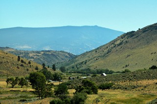
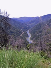 After the market, we headed up into the Sierra Nevada’s to the town of Keddie. It’s a 70 mile drive each way and most of it, on the way there, is up the Feather River Canyon. The highway is built into the side of the mountains and at some points the valley, right at the edge of the road, is close to 1,000 feet down . In this picture the valley is wider than during most of the drive.
It is spectacular!
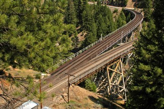 But Keddie is also known to rail fans as the place where the track exits from a tunnel and “Y”s immediately on bridges. The mountains are so close together and the sides are so steep that there isn’t any flat land to build the junctions - thus the bridges.
After getting an oil and filter change on Monday (yes, we do keep the maintenance done on the truck since it is so important to us) we headed up the valley on Tuesday, the 28th, This area is filled with orchards, vineyards, all kinds of berries, potatoes and as we went north, huge herds of cattle.
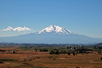
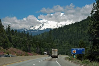 Arriving from the south, you catch glimpses of Mount Shasta as you head into the mountains. We had no idea that the second highest mountain in North America was in the area we were going to. It is 14,162 feet high. We camped outside the town of Weed for 3 nights and were able to tour this dramatic mountain. You can drive up to the 6,900 feet height on a good paved road, but very twisting and quite steep. From there, trails go up to the glacier and many people were starting to make the climb. We met one young man who had climbed to the base camp, which is on the glacier, the day before and that morning had climbed the rest of the way to the top. He then snowboarded down the mountain from the top to about 1/2 mile from where we were parked and it took him only 50 minutes. He certainly was fit.
Mount Shasta dominates everything around and as we left on Friday morning July 1st, to go north into Oregon, we had some of the best views of her.
Now, it’s up the long haul over Siskiyou pass and into Oregon.
Posted by Ross at 11:02 AM | Comments (0)